|
| |
|

|
alms66
|
|
Louisiana
Oct 1999
time: 23:14
|
|
Just in case there could be any confusion from the previous list, I'll post here a complete list of every individual tile set* that will be drawn. This list doesn't include 'overlays' such as roads, rivers or such, just the base 'natural' terrain layer.
*Tile set includes the base tile, 8 extending transitions, 4 'V' transitions, 4 'U' transitions, 1 "surrounded" transition, 1 "coastal transition", and (if no one objects) 1 "feature" tile. The "feature" tile will be similar to 'bonus grassland' in civ, but will be only a graphical property of the tile. Example feature tiles for a Flat tile would be a pond, some trees, an animal or a boulder. Only one variety of each tile set will be drawn for now, however, I will do more varieties later, so the code still needs to be set up to randomly use these varieties based on the number available.
Also note that in my previous count of 43, I missed two, so the actual number is 45. The list is in alphabetical order:
Arctic Volcano
Arctic Volcano, Forest
Coastal
Desert (typical dry, rocky desert)
Dunes (sandy desert)
Flat
Flat, Forest
Flat, Jungle
Glacier (perhaps 'Icecap' is a better term for this?)
Lake (freshwater)
Ocean
Plain (drier flat - I assume)
Plain, Forest
Plain, Jungle (If this is drier flat - probably should drop this)
Rolling Arctic Hills
Rolling Arctic Hills, Forest
Rolling Arctic Mountain
Rolling Arctic Mountain, Forest
Rolling Desert Hills
Rolling Desert Mountain
Rolling Hills
Rolling Hills, Forest
Rolling Hills, Jungle
Rolling Mountain
Rolling Mountain, Forest
Rolling Mountain, Jungle
Rugged Arctic Hills
Rugged Arctic Hills, Forest
Rugged Arctic Mountain
Rugged Arctic Mountain, Forest
Rugged Desert Hills
Rugged Desert Mountain
Rugged Hills
Rugged Hills, Forest
Rugged Hills, Jungle
Rugged Mountain
Rugged Mountain, Forest
Rugged Mountain, Jungle
Sea
Swamp
Tundra
Tundra, Forest
Volcano
Volcano, Forest
Volcano, Jungle
|
|
| |
|
|
|
LDiCesare
|
|
La Ferté sous Jouarre France
Jan 2001
time: 05:14
|
|
I would rather have a flat sand desert and dunes as sandy desert hills. I don't know for big scale if flat sand makes much sense, but for small maps it certainly does.
|
|
| |
|
|
|
alms66
|
|
Louisiana
Oct 1999
time: 23:14
|
|
Since all we're doing currently is small scale scenarios, I may as well go ahead and make one, however, I don't believe it is needed for a full-world scenario.
|
|
| |
|
|
|
alms66
|
|
Louisiana
Oct 1999
time: 23:14
|
|
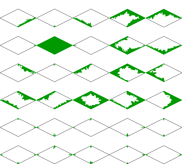
And also, the tile template has been updated, for anyone who might be interested. There were some missing variations (12 of them) which, when added in, brought the total to 30 tiles in the set. I've attatched an example of the template (extra space for variations was removed), which should have all the transitions we need (I've checked this against other games that use these types of transitions), but if you happen to see one missing, let me know.
|
|
| |
|
| |
|
|
|
alms66
|
|
Louisiana
Oct 1999
time: 23:14
|
|
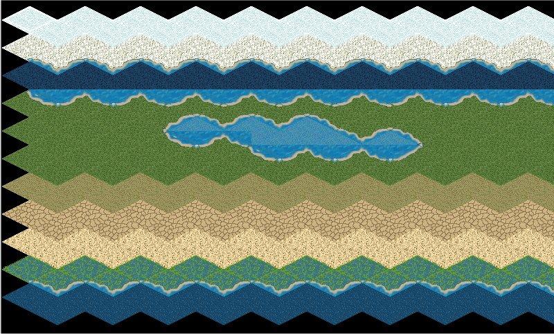
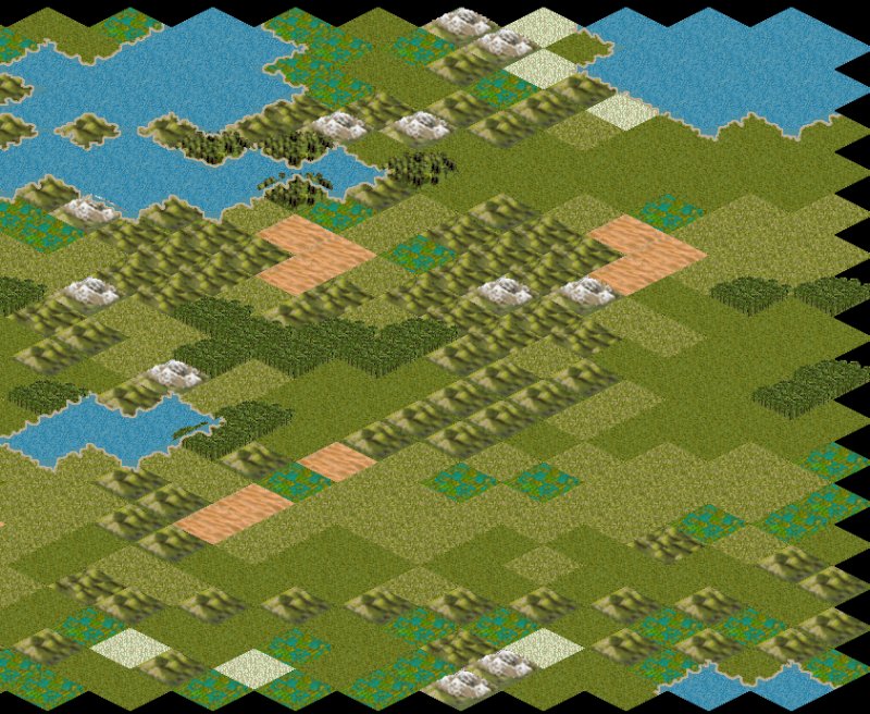
Here's an in-game shot of several terrain tiles. From top to bottom they are:
Glacier
Tundra
Ocean
Flat (with a few Lake tiles)
Plain
Desert
Sand (is this what you had in mind for sandy desert Laurent?)
Swamp
Sea
The old coast tiles are still in, and they are waaay off color-wise compared to the new tiles, so the whole image looks a bit screwy, but it's clear enough. I haven't gotten the tiles perfectly seamless yet either. The swamp is really noticeable. Unlike the existing tiles, these are perfect-fitting, meaning there is a sudden stop where the tile ends. Later, we'll add in transition overlays to smooth this out.
Anyhow, any and all comments are welcome.
-Edit-
Fixed spelling error.
 Attachment: new terrain.jpg Attachment: new terrain.jpg
This has been downloaded 53 time(s).
Last edited by alms66 on 08-12-2004 at 00:23
|
|
| |
|
|
|
alms66
|
|
Louisiana
Oct 1999
time: 23:14
|
|
I'm working on the coastlines now, and it has made me realize that we really need to code tile varieties sometime soon (by soon I mean soon after demo 8 is out). I'm drawing some extremely detailed coastlines that look great, but they are far too repetitive because of that detail. If varieties were in, I could probably crank out a new variety of coastline every three days or so, which means that if it were to take two weeks (just pulling numbers from thin air here) to code the change, I could have 4-5 varieties of coastline ready to go at that point. 
So I don't have to go find the post (and since I can relate this directly to Clash a bit more than last time), I'll explain the tile varieties idea here again. Basically it requires adding one variable to the mapTile class called 'variety'. This variable tells you which image to display, for example is it flat variety 1, variety 2 or variety 3? In 'terrain.xml' (I assume this is the best place for it) we could (*) define the number of varieties for each tiletype present in the tile folder. For example, let's say I had 5 varieties of desert tiles. I would then have these images:
desert1
desert2
desert3
desert4
desert5
...etc., etc.
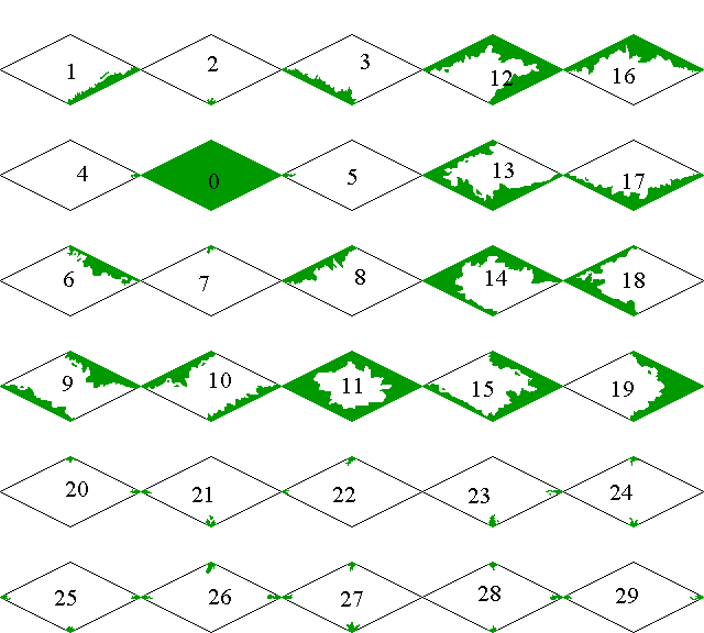
In fact, planning for the eventual use of transition overlays, we have here a naming convention that would eliminate the need to have terrain images defined in 'images.xml' and ‘terrain.xml’ entirely. For example let's break down what ‘desert1’ means. Well, desert is obviously the tiletype. The number 1 indicates the variety. Now we add a second number 1 to indicate the transition number (actually the remaining numbers because this will go to two digits). So desert11 indicates the desert image-variety 1-transition 1, desert420 indicates the desert image-variety 4-transition 20, and flat20 indicates the flat image-variety 2-transition 0 (transition 0 is the full tile).
Varieties could be randomly determined by the computer, or, if we want to give ultimate graphical control to scenario designers, we could add a new array in the ‘scenario.xml’ file so the designer can choose exactly which variety he wants displayed at any given tile.
*I want to stress could here, because we could also just read the tiles and determine the number of varieties rather than leaving it up to the scenario designer, which is probably the better way to do it in the long run.
And finally, an example of transition numbers:
 Attachment: transition numbers.gif Attachment: transition numbers.gif
This has been downloaded 48 time(s).
|
|
| |
|
|
|
alms66
|
|
Louisiana
Oct 1999
time: 23:14
|
|
I've made some changes to the images.xml file. I've organized it (in preperation for some new images I'll be adding for the technology scenario) a bit and renamed some images to match their terrain type (for example, hills.gif was renamed to rollinghills.gif and the xml file now matches). I'd like to upload this to the server, but, I don't use the standard graphics, I've overwritten mine with some tweaked graphics. I've made the roads and coastlines thinner (and more detailed coasts), lightened most of the other tiles, taken out that white spot in the broken tile, and completely redone the tundra.
So, could anyone that has on opinion on the matter vote yay or nay to the terrain tiles in the following images being uploaded into the repository (they would overwrite the existing ones, as I have done in my local version)?
If the vote is nay, I'll just adjust the terrain.xml file to work with the standard graphics, but maintain the organization before uploading it.
Attachment: terrain.jpg
This has been downloaded 37 time(s).
|
|
| |
|
|
|
alms66
|
|
Louisiana
Oct 1999
time: 23:14
|
|
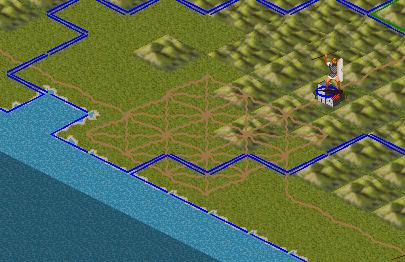
And the roads (which need a little thinning at the center)...
Attachment: roads.jpg
This has been downloaded 38 time(s).
|
|
| |
|
|
|
vovan
|
|
Alms, as far as the images are concerned, I like what I see, so I personally, don't particularly mind if you overwrite the existing images with your updates.
However, I want to point out that you don't necessarily have to overwrite the whole images directory in the repository. You can update files one-by-one, and pick which files to update and which to leave as they are. For example, in order to rename the file hills.gif into rollinghills.gif, rightclick the original file, and pick TortoisSVN -> Rename... (assuming you are using tortoise; then type in the new name, click OK, and then rightclick the renamed file, and hit Commit... That will commit only that one file, and the rest of your changes that you don't really want committed will remain local.
Also, you could right-click the tiles folder, and click Commit. In the dialog that asks you for an explanation of your changes, you can also uncheck those files that you don't want to commit to the repository.
Vovan
|
|
| |
|
|
|
alms66
|
|
Louisiana
Oct 1999
time: 23:14
|
|
Thanks Vovan. I am using tortoise. It's an extremely excellent piece of software for being free.
I have yet to commit anything thus far, so that pretty much confirms that I know how - and I was planning on only commiting the changed files, it's just that what I've changed requires an overwrite of existing files.
-Edit-
Also, would you guys like me to add a "grid" to the tiles so that players can see a grid like in civ? This would be a temporary hack until we do a proper grid.
Last edited by alms66 on 31-12-2004 at 09:42
|
|
| |
|
|
|
LDiCesare
|
|
La Ferté sous Jouarre France
Jan 2001
time: 05:14
|
|
The tiles look ok to me.
What do you propose for the grid? I certainly don't want it on all the time.
|
|
| |
|
|
|
alms66
|
|
Louisiana
Oct 1999
time: 23:14
|
|
I was going to make a copy of the tiles and draw a gray line for the grid. It would be on all the time though. Unless you felt compelled to code something for it. I can live without the grid, but I know some people can't play civ without it, that's why I asked.
|
|
| |
|
|
|
LDiCesare
|
|
La Ferté sous Jouarre France
Jan 2001
time: 05:14
|
|
I often use Ctrl-G while playing civ, but I don't want it on at all times, so I'd rather not have it. Coding something for it should go on our to do list (buried somewhere...)
|
|
| |
|
|
|
alms66
|
|
Louisiana
Oct 1999
time: 23:14
|
|
quote:
Originally posted by Mark_Everson
Looks ok to me. The only thing I don't like is that the spillover of land gfx into the water for coastal squares seems even worse than it was before. One request, could you do a before and after image next time you propose changes so that it's easy to compare? |
I haven't gone back and fixed that yet. I plan to before uploading it though. It's just such a pain to do 46 tiles in a row. You really don't need 46 coastal tiles. Most of them can be compiled from smaller components, probably cutting the number in half. Sure, it might require drawing 3 overlays where you could have drawn one, but it puts those precious artist resources to good use when you economize things like this. I'll have to add this to the request list too.
quote:
Originally posted by Mark_Everson
I don't know about others, but I'd also like the roads to be a bit more noticeable. I often have to squint at the map to see the roads clearly, especially while they are starting to be built. If nobody else has this issue, then it's not that important. |
I can brighten the roads a bit. That should make them more noticeable.
|
|
| |
|
|
|
alms66
|
|
Louisiana
Oct 1999
time: 23:14
|
|
I agree, the hills are a bit off. Partly from the origional artist, partly from my changes. I did too much cut N' pasting on the rugged hills, for example. I think I'll just redraw them to match the flat tile's texture a bit better, something they didn't do very well in the first place, IMO. I'll see if I can get a temporary fix on it though. The rolling hills have no changes what so ever, except to make them perfect fitting, as all the other tiles are now (I removed all the black edges to the tiles). I suspect this is your issue with the flat and plains tiles as well, though I do want to add some 'stalks' of grass rising out of the plains tile..
Hills, Mountains and Trees - the elevated stuff, takes quite a bit longer to do than the flat tiles (plains, flat, tundra, etc.), which is why I changed my approach, and saved them for last. If you think you can live with it until then (with the temporary fix), I'll just finish getting the flat tiles cleaned up and then do the hills as the very first thing once I start on the elevated tiles again.
|
|
| |
|
|
|
LDiCesare
|
|
La Ferté sous Jouarre France
Jan 2001
time: 05:14
|
|
(Posted in wrong thread...)
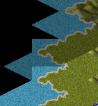
One coast tile seems wrong:
 Attachment: coastbug.bmp Attachment: coastbug.bmp
This has been downloaded 3 time(s).
|
|
| |
|
|
|
alms66
|
|
Louisiana
Oct 1999
time: 23:14
|
|
That's the price we have to pay to get rid of trees in water, unless we change coastal tiles to extend into water, not land as they currently do.
|
|
| |
|
|
|
alms66
|
|
Louisiana
Oct 1999
time: 23:14
|
|
If I were to insert a new terrain type called “Sea”, would this work in the terrain.xml file?
code:
  <Image>
    <Default>Coastal</Default>
    <technology>
      <name>Water Transportation</name>
      <knowledge>2.0</knowledge>
      <image>Sea</image>
    </technology>
  </Image>
The intended effect is that all water tiles look the same (and for all intents and purposes are the same from the player’s perspective) until you reach Water Transportation level 2.0, then the Sea tiles look like sea (ocean tiles will be affected in a similar way though they change much later). While the code isn’t there yet AFAIK, later we’re supposed to have attrition affect certain units in certain terrain, and I’m hoping that this will force players to be cautious with sea exploration, otherwise they’ll end up on a sea square and just might loose the entire fleet (though that should be an extreme case of attrition). I don’t want to physically block certain units from moving into certain tiles (as in CTP2, galleys couldn’t enter deep ocean) as that is too easy and no fun as there is no risk involved, and I don’t want an arbitrary chance of the unit sinking (as in Civ), though attrition is good as has been described around here before. I’m not really sure if this approach would be better though. It opens up a realm of unknown for the player, but I don’t know if it would be any fun. Like I said, not being able to tell if that coastal tile you’re moving to is really a coastal tile or a sea tile in disguise would force players to be cautious. But it could force them to be too cautious and feel as though this is something they have to micromanage. Personally, I feel that if we only use attrition, then all the player has to do is avoid the tiles that cause it, which is easy (too easy) but again I don’t know if this will be fun or micromanagement hell. What do you guys think? Should we give it a try?
Also, note that the name would have to change in a similar manner, otherwise the player could simply select all the tiles on the desired path to see if they are really coastal or not, and that’s a bunch of micromanagement.
|
|
| |
|
|
|
alms66
|
|
Louisiana
Oct 1999
time: 23:14
|
|
Or, we could change the movement line paths from red (currently) to green and have them turn yellow as a warning (only those segments affected) and red when no movement is suggested (again, only those segments). There can be varying degrees of intensity between the green->yellow->red. If no movement were allowed at all (such as no wheels on mountains), the path could be blue, white, or some other equally distinct color.
I think that could work well. We'll see what Laurent, and others, think about it.
|
|
| |
|
|
|
LDiCesare
|
|
La Ferté sous Jouarre France
Jan 2001
time: 05:14
|
|
There's not too much needed to change the image of the terrain that way.
Handling shown paths is another matter. First if you want safe/unsafe modes, then it needs some specifics which would go into the pathfinding. The real thing pathfinding needs now is to NOT know the nature of black tiles. That's more important, but not planned now. As for drawing green/yellow/red, it's even further since it requires the safe/unsafe info first.
|
|
| |
|
|
|
LDiCesare
|
|
La Ferté sous Jouarre France
Jan 2001
time: 05:14
|
|
I added an overlay of a "capital" image to the terrain when the tile holds a capital. I reused a city graphics for now, which is not really good for two reasons:
1) There isn't really a city there
2) If there is one with a different image, it will look ugly.
We already have many things shown on a tile, most of them in the same place:
- Terrain.
- Rivers/coasts/borders on the sides.
- Units in the middle, with a power circle.
- City graphics in the middle.
- Fortifications graphics in the lower middle.
- Specials, usually on the left of the tile.
I added recently an icon to show a combat occurred. This icon is currently a pair of crossed swords in the lower middle part of the tile.
The capital overlay has been suggested as a star, but where should it be put? The only place left is the right of the tile, since the top is hidden by the units there.
Is there anything else we want to show on a tile, and where?
|
|
| |
|
|
|
LDiCesare
|
|
La Ferté sous Jouarre France
Jan 2001
time: 05:14
|
|
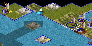
Here's an example of the result putting a star on the right of the tile (walls are not ok as they are drawn afterwards, but I'm not sure it would be nicer if the walls were under the star).
Attachment: stars.jpg
This has been downloaded 21 time(s).
|
|
| |
All times are GMT. The time now is 05:14.
Apolyton Time is 00:14. |
top of page
|
|
|
Forum Rules:
You may not post new threads
You may not post replies
You may not post attachments
You may not edit your posts
|
HTML code is ON
vB code is ON
Smilies are ON
[IMG] code is ON
|
|
|
|
|
|





 03-10-2004 01:41


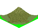
 I decided to work on the rolling hill set first since the flat tiles are so much easier to do. It turned out to be much more difficult to draw than I could have ever imagined. However, I finally got something which, I believe, is a good look for the tile.


 . It looks like it'd be tough to match your concept with any flat tile. . . am I missing something?
 |
|