|
| |
|

|
Harlan

|
|
Berkeley, CA, USA
Aug 2005
time: 21:15
|
|
Locutus,
Reason I don't have America maps? I have a wish list of about 6 scenarios I'd most like to make, if I didn't have a real job and could do nothing but make scenarios all day  . All of them take place in the Old World somewhere or another, so my focus in collecting maps has been there. There are so many America maps, esp. US maps, that to add those would double the size of the website if I had them all. I'm not up to that, but if someone has maps of the Americas and wants to send them to me, I'll be glad to add them. . All of them take place in the Old World somewhere or another, so my focus in collecting maps has been there. There are so many America maps, esp. US maps, that to add those would double the size of the website if I had them all. I'm not up to that, but if someone has maps of the Americas and wants to send them to me, I'll be glad to add them.
Josef,
Bad news. The style of that map looks very familiar. I'm almost 100% sure that I know of that atlas, and in fact have numerous scans from it already on the website. Take a closer look and let me know if there's something you recognize. I'm bummed out, cos that dashes my hopes that there's a whole other excellent atlas out there I didn't know about. 
Marquis,
I'd love some of these maps you mention. The satellite imagery combined with elevation and who knows what else data sounds great. Bring it on! I was able to look at the vegetation map as well, but it seems to me to be not nearly the quality of the other image you posted. The categorization seems way over simplified, for instance Turkey having just a few vegetation zones. Even without humans the situation is much more complicated than that, with pockets of different terrain types here and there. I'm sure there are better maps of this. There are some maps on my website that have more detail, for instance.
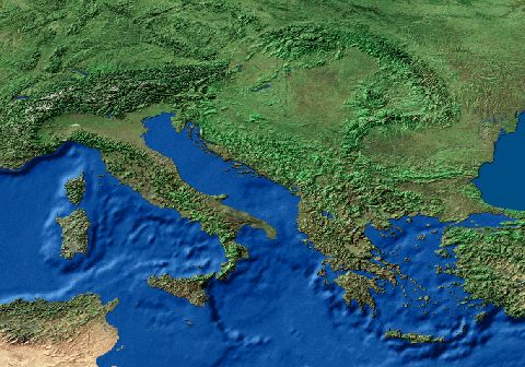
But hey, that satellite image is fantastic, probably the best I've seen for this purpose, without annoying things like labels getting in the way, or different perspectives for different maps. Gimme gimme gimme! And a world wide elevation map would be even better to have for scenario making purposes.
I hope that Civ3, like CTP and Civ2, will have a map conversion program either made by the company or by a clever fan, so one can shoot in a map scan and spit out a Civ3 map. The maps you've got could boost the accuracy of that even more.
|
|
| |
|
| |
|
|
|
Marquis de Sodaq
|
 |
... no, a Marquis.
Jul 2000
time: 23:15
|
|
quote:
Originally posted by Harlan
...I was able to look at the vegetation map as well, but it seems to me to be not nearly the quality of the other image you posted. The categorization seems way over simplified... |
Yes, it is a very general categorization. However, I'd originally pulled it together because the vegetation classes are more or less as general as CivII terrain types. It does not go into local detail, either, which would be preferable for smaller areas, such as Turkey. I can search for other data. The one problem to expect with detailed information is availability - Not all places have such data. However, for example, if there is a Turkish GIS agency that allows public access to its data, it would be only a small task to convert that into a useable format.
|
|
| |
|
|
|
Marquis de Sodaq
|
|
... no, a Marquis.
Jul 2000
time: 23:15
|
|
quote:
Originally posted by BeBro
Marquis, I use raytracing software at home, with a "built in" 3d landscape generator, but it can only generate fictional landscapes. I read somewhere that some (unfortunately expensive) software packages can read satellite DEM data to create absolutely exact Earth landscapes and maps, but I cannot recall where I read this, therefore my question... |
Sadly, these software packages typically are not affordable for the home PC. Processing real DEM data requires much RAM and the software to do it. A world image such as the one I have has an elevation point every 2 km or so - a 50mb file. The resulting image is shaded from a single point (the virtual sun), and then colored with a satellite image to give it the "real" color scheme. It's good, but does not work any closer than about 1:12,500,000 - around Greece to the Caspian on your monitor. Zooming closer in would require a more detailed image.
|
|
| |
|
|
|
JosefGiven
|
 |
Tavistock, Devon, UK
Jan 2001
time: 05:15
|
|
quote:
Originally posted by Harlan
Josef,
Bad news. The style of that map looks very familiar. I'm almost 100% sure that I know of that atlas, and in fact have numerous scans from it already on the website. Take a closer look and let me know if there's something you recognize. I'm bummed out, cos that dashes my hopes that there's a whole other excellent atlas out there I didn't know about. |
Yeah, you have seen it before, mate.
This Roman Economy Map, 180 AD can be found on page 89 of this mightiest of tomes.
Nevertheless, I'll continue to keep an eye on this thread. Although, as I say, the main maps are two-page spread big muthas that won't fit onto my scanner, each page does have several smaller inset maps with more obscure, quirky information. So if you do ever need an obscure political/resource/whatever map, this book probably has something like it, as you probably know.
Chances are, though, that this thread will slip off page one into the dark, ne'er explored, uncharted regions of page two and even further. If and when that happens, know that I'll always be on stand-by to provide scanned map support at josefgiven@hotmail.com 
quote:
I hope that Civ3, like CTP and Civ2, will have a map conversion program either made by the company or by a clever fan, so one can shoot in a map scan and spit out a Civ3 map. The maps you've got could boost the accuracy of that even more. |
Yeah, me too. Quite how many hours of work a utility like that would save doesn't bear thinking about.
All the best,
Josef
|
|
| |
|
|
|
Harlan
|
|
Berkeley, CA, USA
Aug 2005
time: 21:15
|
|
Phew - close call, I just saved this thread from that dreaded page 2 oblivion!
I do hope I can find a new home for it soon, or else the only people to know of the website will be the few who saw this thread.
XarXo,
I don't have Antarctica maps cos let's face it, there aren't a ton of Antartica-related scenarios. Has there in fact ever been one - I'm curious.
Marquis,
I wouldn't worry too much about the vegetation stuff. Like I said, I already have some decent stuff up. But if you come across better, please let me know.
I still would very much like your satellite and DEM imagery. Could you email me some of that? 50 MB is pretty whopping, but if you were to cut it down to just the Old World, and then save it as a .jpg, I'm sure it would be much smaller. Esp. as it could be broken into pieces - I can deal with about 5 MB max at a time. Elevation data shaded from a single point isn't ideal. What would be much better is that data presented in typical topological map form, with 1000 meters, 2000 meters, etc marked off (or feet - you get my point). I already have a shaded relief map of the Old World that I haven't put up yet, though it would be nice to have one that exactly matched the other map data. Can you also get that or convert it to different projections?
Josef,
You may stand behind your "mightiest of tomes", but I'm quite a fan of the Hammond Atlas of World History. I think that one compares very well with the Times Atlas.
|
|
| |
|
| |
|
|
|
izmircali
|
|
Izmir, Turkey
Sep 2001
time: 05:15
|
|
Does anyone know how resources will work exactly? I saw some info that if you only have one resource square of say horses and you decide to trade it, then you won't have that resource. So is it that if you have one square you have unlimited amounts of that you do acquire like 1 horse per turn per horse squares you have and you can stockpile or trade set amounts or certain units require certain amounts?
|
|
| |
|
| |
|
|
|
CobraA1
|
 |
North of the Arctic Circle, south of Canada; Minnesota, USA
Sep 2001
time: 21:15
|
|
quote:
Originally posted by BeBro
Marquis, I use raytracing software at home, with a "built in" 3d landscape generator, but it can only generate fictional landscapes. I read somewhere that some (unfortunately expensive) software packages can read satellite DEM data to create absolutely exact Earth landscapes and maps, but I cannot recall where I read this, therefore my question... |
quote:
Originally posted by Marquis de Sodaq
Sadly, these software packages typically are not affordable for the home PC. Processing real DEM data requires much RAM and the software to do it. A world image such as the one I have has an elevation point every 2 km or so - a 50mb file. The resulting image is shaded from a single point (the virtual sun), and then colored with a satellite image to give it the "real" color scheme. It's good, but does not work any closer than about 1:12,500,000 - around Greece to the Caspian on your monitor. Zooming closer in would require a more detailed image. |
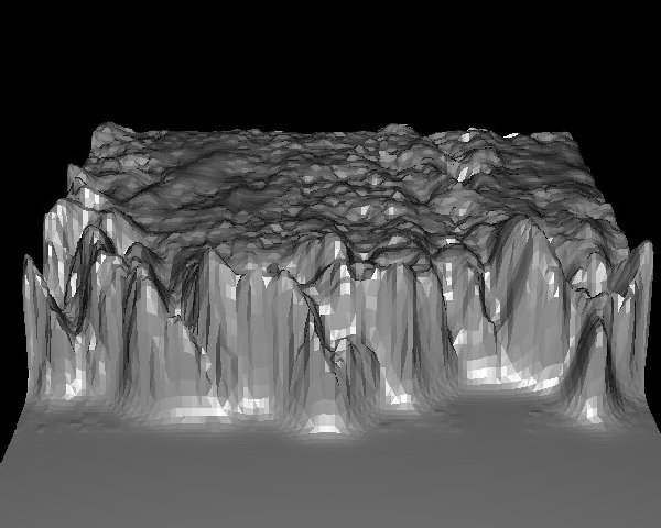
Here's a nice piece of terrain-editing software that can read some forms of DEM. It also supports BMPs and a few other file formats. Best of all, it doesn't cost a dime. It's amazing what you'll find if you look hard enough  . .
http://www.ridgenet.net/~jslayton/software.html
|
|
| |
|
|
|
Harlan
|
|
Berkeley, CA, USA
Aug 2005
time: 21:15
|
|
Waku,
Neat link, though I knew of it before. I'm not gonna add satellite images from there just yet though, cos I'm hoping Marquis will come through on his.
Iz,
While your question does appear off topic to this thread, I'll make a stab at an answer. In the horse example, if you're keeping the 1 horse resource to yourself, that should enable you to build units needing horses anywhere. If you've got 2, you can trade one away. Anything over that would be gravy. However, they've also said the resources can disappear after they've been used up. Plus new ones can be discovered in territory you already have explored, if you're working that land.
What would be really cool is if resources get used up faster if they're being used faster. For instance, if you're using that one horse to build lots of units it should be used up faster than if you're using it to only build one unit. If that's the case, then you can never have enough strategic resources. Perhaps wishful thinking on my part...
CapTVK,
Man alive! If you could send me maps from the National Geographic stuff, that would be beyond amazing. NG is great at making historical maps that show things like trade, roads, religion, culture, etc... I'd love to have that on my site! Is there any kind of index you could send me so I could see what the maps are of, and maybe there are some serious gaps I could point out that especially need filling.
|
|
| |
|
|
|
Marquis de Sodaq
|
|
... no, a Marquis.
Jul 2000
time: 23:15
|
|
quote:
Originally posted by Harlan
Marquis,
I wouldn't worry too much about the vegetation stuff. Like I said, I already have some decent stuff up. But if you come across better, please let me know. |
As I mentioned, this usually requires a data search. This, in turn, calls for a particular area you'd like to find. The US has piles of data, europe usually has good data, too. The rest of the world is not as reliably digital, as could be expected.
quote:
Originally posted by Harlan
I still would very much like your satellite and DEM imagery. Could you email me some of that? 50 MB is pretty whopping, but if you were to cut it down to just the Old World, and then save it as a .jpg, I'm sure it would be much smaller. Esp. as it could be broken into pieces - I can deal with about 5 MB max at a time. |
Reducing detail is the quickest way to reduce file size. The resulting image is still usable (see the one I posted above), but has generalized, for example, 9 pixels into 1. Voila, a file many times smaller.
quote:
Originally posted by Harlan
Elevation data shaded from a single point isn't ideal. What would be much better is that data presented in typical topological map form, with 1000 meters, 2000 meters marked off... |
Moving from elevation to contours is not hard. The color image I posted above, tho, is no longer elevation data. I'd have to create something anew for that. That means time, of which I have little extra while I'm at work! I'll see what I can pull together in the next few days as an example.
quote:
Originally posted by Harlan
Can you also get that or convert it to different projections? |
Happily, the technology for projecting raster data is getting faster. It used to take several days of processing time to convert a huge grid to a new projection. Now it's on the scale of hours or less. A smaller grid is vastly preferable in this case.
|
|
| |
|
|
|
Harlan
|
|
Berkeley, CA, USA
Aug 2005
time: 21:15
|
|
"As I mentioned, this usually requires a data search. This, in turn, calls for a particular area you'd like to find. The US has piles of data, europe usually has good data, too. The rest of the world is not as reliably digital, as could be expected."
Contintental wide stuff is preferrable, Old World only. Something Europe wide would be great, if that is obtainable.
"Reducing detail is the quickest way to reduce file size. The resulting image is still usable (see the one I posted above), but has generalized, for example, 9 pixels into 1. Voila, a file many times smaller."
True, but that should be the choice of last resort if all else isn't enough. Zipping, cropping, changing sav formats all reduce size alot too.
"Moving from elevation to contours is not hard. The color image I posted above, tho, is no longer elevation data. I'd have to create something anew for that. That means time, of which I have little extra while I'm at work! I'll see what I can pull together in the next few days as an example."
Cool - thanks!
"Happily, the technology for projecting raster data is getting faster. It used to take several days of processing time to convert a huge grid to a new projection. Now it's on the scale of hours or less. A smaller grid is vastly preferable in this case."
If you do find some good elevation and/or vegetation data for Eurasia, I'd love to see it converted from whatever to Two Point Equidistant Projection, Poles at 35 degrees North, -40 degrees East, and 35 degrees North, - 140 degrees East. Talk about a tall order! But that's the best projection for fitting all of Eurasia into a rectangular box, and I have plans eventually for a scenario that covers all of Eurasia, using that projection.
Thanks everyone, by the way, for all the positive comments and suggestions coming in. That helps inspire me to keep working to make the resources on the site better.
|
|
| |
|
| |
|
|
|
Harlan
|
|
Berkeley, CA, USA
Aug 2005
time: 21:15
|
|
Josef,
I'm 100% sure now that comes from a different atlas. However, I'm sure your atlas has other Russia stuff, like isn't there a gulag related map, and an ethnic groups of Russia map? I know there was something Russia related that I forgot to get!
Darkknight,
You took a bit of what map? I don't know of any map right now with elevation data.
CapTVK,
If you're having trouble making images, I suggest you go to www.download.com, and download a program called Hypersnap. Its free, and enables you to get screenshots from just about any program. Its never failed for me. The free version puts a little logo in the image you save, but its almost always on top of the drop down menu anyways, so it doesn't matter.
|
|
| |
|
|
|
Triped
|
|
Caledonia, Illinois, USA
Sep 2001
time: 23:15
|
|
That should work..Blender is a nice program.
|
|
| |
|
| |
All times are GMT. The time now is 05:15.
Apolyton Time is 00:15. |
top of page
|
| archivepost |
|
Forum Rules:
You may not post new threads
You may not post replies
You may not post attachments
You may not edit your posts
|
HTML code is ON
vB code is ON
Smilies are ON
[IMG] code is ON
|
|
|
|
|
|





 21-09-2001 04:53


 .
.


 Attachment:


 |
|