|
| |
|

|
Harlan

|
|
Berkeley, CA, USA
Aug 2005
time: 21:15
|
|
Hi,
I've been collecting maps for a long time. With Civ3 coming out soon, I've decided to make a lot of them available to help scenario makers out. Hopefully this will help make scenarios achieve a higher level of quality than in Civ2.
I've thrown them up onto a website, which you can check out at:
http://www.earthisland.org/borneo/other/index.html
However, there are several problems. The first is that the site is now on my work website, and can't stay there for long! Markos, I've emailed you several times about hosting it on Apolyton, but haven't heard back. If anyone else has hosting ideas, I'm all ears, and need something fast.
Second problem is that 99% of the images there are probably trampling copyright laws, so I'd appreciate it if you keep this website low key, and don't link to it or anything, at least until I can figure out the copyright issues.
Thanks.
|
|
| |
|
| |
|
| |
|
| |
|
|
|
Harlan
|
|
Berkeley, CA, USA
Aug 2005
time: 21:15
|
|
Hendrik,
Thanks, I'll fix that. If that's the only one, I'd be surprised, cos I threw the website together in one evening. I haven't actually tested anything out except in the most cursory way, so please let me know if you see anything else wrong. The main problems are likely to be thumbnails pointing to the wrong thing, and labels referring to different maps than what the thumbnail shows.
Josef,
That book sounds very interesting. Any chance you could scan some of those great maps in? (the ones that fit the mandate of the website: showing economy, terrain, trade, roads, culture, religion, etc.. and not political boundary maps) I tried looking the book up at Amazon, and got The Sunday Times History of the World Cup instead, as the nearest match I guess.  The ISBN number didn't help, but maybe I didn't get the spacing right or something. The ISBN number didn't help, but maybe I didn't get the spacing right or something.
|
|
| |
|
|
|
JosefGiven
|
 |
Tavistock, Devon, UK
Jan 2001
time: 05:15
|
|
quote:
Originally posted by Harlan
Josef,
That book sounds very interesting. Any chance you could scan some of those great maps in? (the ones that fit the mandate of the website: showing economy, terrain, trade, roads, culture, religion, etc.. and not political boundary maps) I tried looking the book up at Amazon, and got The Sunday Times History of the World Cup instead, as the nearest match I guess. The ISBN number didn't help, but maybe I didn't get the spacing right or something. |
Hmm, I tried checking that ISBN number out on a few sites and got nothing back...confusing, since I had the very book in front of me...Odd, that. I did a swift search using a site called Bookbrain, which did track it down, and I think the 'official' name of the book, from a publisher's point of view is:
"Times" History of the World, The Ultimate Work of Historical Reference by Overy, RJ
The only problem is, it costs a princely £50, which is what, US$ 70-75?
Are there any specific periods from history or geographical regions you want scans from, mate? To be honest, I'm a bit nervous of splaying this beautiful book over my scanner, and having to wrench at it's spine to get it flush with the scanner's surface. But then, if I can provide the cause with some decent material without wrecking the book, I'll do what I can.
BTW, what did you make of the stuff at the end of that link I put in my last post?
Josef
|
|
| |
|
|
|
Harlan
|
|
Berkeley, CA, USA
Aug 2005
time: 21:15
|
|
Raskaldan,
Thanks, keep em coming, and I'll fix them tonight. I don't know of a quick painless way to download lots of stuff, sorry.
Josef,
I would love some scans from the book. At least send one so I can see what the book is like. As far as what stuff to scan in particular, things that follow the criterion for the website (trade goods, roads etc as mentioned below), and are about years and/or places not already covered would be the best. I esp. like maps that show city sizes.
I was already familiar with the link you included. Most of it I wasn't impressed with. Seems to me there aren't that many good maps on the web, except the common political boundary types.
|
|
| |
|
| |
|
|
|
TCO
|
 |
Richmond, VA
Jan 1970
time: 00:15
|
|
quote:
Originally posted by Harlan
Hi,
I've been collecting maps for a long time. With Civ3 coming out soon, I've decided to make a lot of them available to help scenario makers out. Hopefully this will help make scenarios achieve a higher level of quality than in Civ2.
I've thrown them up onto a website, which you can check out at:
http://www.earthisland.org/borneo/other/index.html
However, there are several problems. The first is that the site is now on my work website, and can't stay there for long! Markos, I've emailed you several times about hosting it on Apolyton, but haven't heard back. If anyone else has hosting ideas, I'm all ears, and need something fast.
Second problem is that 99% of the images there are probably trampling copyright laws, so I'd appreciate it if you keep this website low key, and don't link to it or anything, at least until I can figure out the copyright issues.
Thanks. |
Maybe Markos doesn't want to host stuff that is copyright violations.
Of course AnnC would say he does...
|
|
| |
|
|
|
JosefGiven
|
|
Tavistock, Devon, UK
Jan 2001
time: 05:15
|
|
Here's a demo image from The Times Histo Atlas.
It's a provincial-political map of Japan under the Shoguns.
The small red and orange arrows you can see coming into the provinces of Chichuzen and Nagato are the routes of Mongol invasions. (Red: 1274, Orange: 1281).
Shogun : Total War veterans will revel in glee that the provincial divisions relate almost exactly to the map in the game of the same name! 

Harlan, I have a much, much bigger image of this map in full 16.7 million colours if you want it, but that's a whopping 11MB big. To be honest, the transition from 16.7m colours to 256 hasn't harmed the image at all, but the text certainly reads easier on the larger sized map.
Unfortunately, most maps in the Times Histo Atlas overlap the hinge, and the bigger ones don't even fit onto my tiny-a$s, came-with-the-computer scanner. If you like the one I've linked in above, I'll post a list of all the maps that I will be able to scan successfully.
All the best,
Josef 
|
|
| |
|
|
|
Marquis de Sodaq
|
 |
... no, a Marquis.
Jul 2000
time: 23:15
|
|
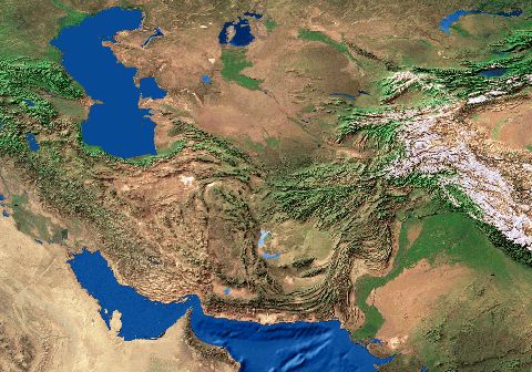
BeBro, the visible graphic is indeed an elevation map. I have one already made for the whole world, and can snip out any particular extents. It is a JPEG (or did I save as TIFF?). I use a software at work that probably nobody, including me, has at home. However, it can be pared down to desired extents with any graphic software.
What is great about this world image is that it is in the same projection as the general world data I have at work - they overlay perfectly. The vegetation classes can be converted to CivII map format, the elevation used as a reference to add mountains and hills. The vegetation class zones data I have is modern, but ignores human "interaction". Basically, what would grow here if we weren't killing all the plants.
Harlan, f you have trouble opening the crescent.bmp with Imaging - getting a popup about a missing .dll - open MS Paint and open it as a file there. If you still have trouble, I can repost it.
|
|
| |
|
| |
All times are GMT. The time now is 05:15.
Apolyton Time is 00:15. |
top of page
|
| archivepost |
|
Forum Rules:
You may not post new threads
You may not post replies
You may not post attachments
You may not edit your posts
|
HTML code is ON
vB code is ON
Smilies are ON
[IMG] code is ON
|
|
|
|
|
|





 18-09-2001 21:07


 WOW! Harlan, what an impressive collection you've got going there. Brilliant job! I'm sure that it will be of invaluable use to the civ community.


 Attachment:
  Attachment:





 |
|