Apolyton Archive  |  Preserved copy of the Apolyton Civilization Site and its forums as they stood in September 2005. Read-only; nothing here can be posted to or replied to.  |  Forum index |  About this archive |  The 1998–2001 UBB forums
Today on Apolyton WARDELL INTERVIEW PROMO A.C.S. HISTORY CHAPTER 4 GET CIV4 /w FREE PLUS! A.C.S. PHOTO GALLERY GET A.O.M. V1.1
Apolyton Civilization Forums
main| civ2| civ3| civ4| smac| ctp2| ron| moo3| galciv| galciv2| alt| about|
ApolytonPLUS | register | search | faq | new posts | pm (-/-) | upload | members
hall of fame new! | civgroups | civgroups news | interviews | the column | radio | chat | directory | news | store | PLUS
Apolyton Civilization Forums : Powered by vBulletin version 2.0.3 Apolyton Civilization Forums > Miscellaneous > Archive > The Spanish Civilization Site - Archive > Civ2- CÓmo Crear Mapas
Show a Printable Version | Email This Page to Someone! | Receive updates to this thread | Report this to Apolyton news!

bottom of page
  
Author
Thread    < Last Thread     Next Thread > Post New Thread     Post A Reply
alf is offline alf
Prince
Bilbao de España,.... espero
May 2001
time: 05:15
  Old Post 01-10-2001 13:37
Edit/Delete Message Reply w/Quote
#1 Report this post to a moderator
Civ2- CÓmo Crear Mapas Full PM-box? Change here!

Fiel a mi costumbre de crear patrones de trabajo, para enterarme de algo de este mundo, para mí tan complicado, del civ2, he decidido abrir una carpeta donde expongáis vuestras opiniones sobre cómo crear escenarios.
Sería muy de mi agrado y creo que de provecho general el que os explicárais con mucho detalle en este área, sin salirnos hacia el futbol, la política y otras áreas interesantes pero diferentes.
He traducido este finde el fichero informativo del MapEdit, he probado el programa y me parece una excelente herramienta para crear mapas, partiendo, eso sí, de un escaneo de un mapa.
Mi traducción es bastante patética, así que me encantaría que alguien q haya manejado esa herramienta o que tenga un brillante inglés, supervise mi penosa traducción por si he metido la pata, como seguramente pase.

Fiera is offline Fiera
Emperor
Proud Member of the Spanish Gang
Mar 2000
time: 06:15
  Old Post 01-10-2001 19:25 Visit Fiera's homepage!
Edit/Delete Message Reply w/Quote
#2 Report this post to a moderator
Support Apolyton, buy GURPS/ Alpha Centauri

Sí, la verdad es que el MapEdit de Jorrit Vermeiren (Mercator por estos pagos) es lo mejor que hay, si partes de un mapa ya escaneado o en formato digital.

Como yo ya he hecho mis pinitos en dibujar mapas "from scratch", es decir, siguiendo "a ojo" el atlas, te diré que lo mejor es superponer, a lápiz, una retícula de casillas, que serán las "tiles" del mapa. Ahora, no pongas los ejes en perpendicular a la hoja del mapa, sino más bien "en diagonal", que es como están orientadas en los mapas de Civ2.

Aún y así, hay que tener en cuenta que el formato de mapas de Civ2 cuenta dos casillas del eje Y (el vertical) por cada una del eje X. Hay dos posibilidades: pintar una subdivisión, que duplique el número de casillas verticales de tu retícula, o (para perezosos, como yo) no pintarla y simplemente, tenerla en cuenta al ir haciendo el mapa.

Así, con esas referencias, puedes hacer un mapa que esté bien orientado y proporcionado en Civ2, pero lleva su tiempo, eh?

Marquis de Sodaq is offline Marquis de Sodaq
King
... no, a Marquis.
Jul 2000
time: 23:15
  Old Post 01-10-2001 22:18 Visit Marquis de Sodaq's homepage!
Edit/Delete Message Reply w/Quote
#3 Report this post to a moderator
Support Apolyton, buy Alpha Centauri

For MapEdit, you must use bitmaps as input. This example is negro/blanco de espana, 192x144 pixels. It can be used for shoreline...

Attachment: espana2.bmp
This has been downloaded 5 time(s).

Marquis de Sodaq is offline Marquis de Sodaq
King
... no, a Marquis.
Jul 2000
time: 23:15
  Old Post 01-10-2001 22:22 Visit Marquis de Sodaq's homepage!
Edit/Delete Message Reply w/Quote
#4 Report this post to a moderator
Inflate your Upload Space

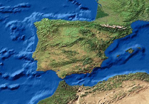
I can make an image like this for any place you want - but no
"closer" to the world than this one. For example, only the area around Lissaboa would not work. I also have general vegetation data for the bitmaps.

Attachment: espana1.jpg
This has been downloaded 49 time(s).

Fiera is offline Fiera
Emperor
Proud Member of the Spanish Gang
Mar 2000
time: 06:15
  Old Post 01-10-2001 23:19 Visit Fiera's homepage!
Edit/Delete Message Reply w/Quote
#5 Report this post to a moderator
Support Apolyton, buy Call to Power 2

Beautiful image, Marquis!

Ahh, qué bonita es España...

alf is offline alf
Prince
Bilbao de España,.... espero
May 2001
time: 05:15
  Old Post 02-10-2001 11:18
Edit/Delete Message Reply w/Quote
#6 Report this post to a moderator
Support Apolyton, buy Galactic Civilizations

quote:
Originally posted by Fiera
Como yo ya he hecho mis pinitos en dibujar mapas "from scratch", es decir, siguiendo "a ojo" el atlas, te diré que lo mejor es superponer, a lápiz, una retícula de casillas, que serán las "tiles" del mapa. Ahora, no pongas los ejes en perpendicular a la hoja del mapa, sino más bien "en diagonal", que es como están orientadas en los mapas de Civ2.
Así, con esas referencias, puedes hacer un mapa que esté bien orientado y proporcionado en Civ2, pero lleva su tiempo, eh?

Sí, por eso es por lo q me inclino por escanear un mapa, darle formato BMP y luego pasarlo por el MapEdit, al final modificar algo con el editor del CIV.
Creo q es el método mas rápido.

alf is offline alf
Prince
Bilbao de España,.... espero
May 2001
time: 05:15
  Old Post 02-10-2001 11:21
Edit/Delete Message Reply w/Quote
#7 Report this post to a moderator
Support Apolyton, pre-order Civilization IV

quote:
Originally posted by Marquis de Sodaq
I can make an image like this for any place you want - but no
"closer" to the world than this one. For example, only the area around Lissaboa would not work. I also have general vegetation data for the bitmaps.

Me gusta tu mapa... es muy bonito, gracias!!

Fiera is offline Fiera
Emperor
Proud Member of the Spanish Gang
Mar 2000
time: 06:15
  Old Post 02-10-2001 17:34 Visit Fiera's homepage!
Edit/Delete Message Reply w/Quote
#8 Report this post to a moderator
Support Apolyton buy from Amazon

quote:
Originally posted by alf
Sí, por eso es por lo q me inclino por escanear un mapa, darle formato BMP y luego pasarlo por el MapEdit, al final modificar algo con el editor del CIV.
Creo q es el método mas rápido.


Está clarísimo.

Supongo que tú ya tendrás algo por ahí, pero si no, te puedo escanear algún mapa de la batalla de Lepanto, para que vayas convirtiéndolo.

alf is offline alf
Prince
Bilbao de España,.... espero
May 2001
time: 05:15
  Old Post 02-10-2001 18:02
Edit/Delete Message Reply w/Quote
#9 Report this post to a moderator
Full PM-box? Change here!

Gracias, pero me he dotado de un libro de Ricardo Cerezo Martinez, "las armadas de FII" que es muy conciso y tiene un sencillo mapa que me vale, que conste q ya habia hecho uno con una guia michelin de grecia.
Por cierto ese libro se refiere tambien a la invencible y si necesita kindal las hojas las escaneo...aunque son un puñao.

Fiera is offline Fiera
Emperor
Proud Member of the Spanish Gang
Mar 2000
time: 06:15
  Old Post 02-10-2001 19:00 Visit Fiera's homepage!
Edit/Delete Message Reply w/Quote
#10 Report this post to a moderator
Inflate your Upload Space

Hmm... un libro que no conozco! Es antiguo o podré encontrarlo por ahí?

alf is offline alf
Prince
Bilbao de España,.... espero
May 2001
time: 05:15
  Old Post 02-10-2001 19:50
Edit/Delete Message Reply w/Quote
#11 Report this post to a moderator
Support Apolyton, buy Galactic Civilizations

es del 88 Editorial San Martin, el nombre completo es, historia de la marina española, las armadas de fII.
El hombre este es capitan de navio.

Shaka Naldur is offline Shaka Naldur
Emperor
Castellón, Spain
May 2000
time: 06:15
  Old Post 02-10-2001 23:45 Visit Shaka Naldur's homepage!
Edit/Delete Message Reply w/Quote
#12 Report this post to a moderator
Support Apolyton, buy GURPS/ Alpha Centauri

no viene al cuento pero como me aburro

hice un mapa de Sudamerica para un escenario q hice tipo Alba de America y Spanish Oddisey antes de q supiera q existia el MGE, y tambien hice otro para el escenario de Waterloo q iba a hacer

personalmente me mola mucho hacer mapas, no se, y eso q no dibujo bien pero hacer los mapas molaba


quote:
Jorrit Vermeiren (Mercator por estos pagos)


en serio? :surprised: :surprised:

Fiera is offline Fiera
Emperor
Proud Member of the Spanish Gang
Mar 2000
time: 06:15
  Old Post 03-10-2001 00:55 Visit Fiera's homepage!
Edit/Delete Message Reply w/Quote
#13 Report this post to a moderator
Support Apolyton buy from Amazon

quote:
Originally posted by alf
es del 88 Editorial San Martin, el nombre completo es, historia de la marina española, las armadas de fII.


Gracias, Alf! Un poco antiguo, pero lo pondré en mi "shortlist" por si lo veo por alguna librería...

Shaka: sí, Jorrit V. es Mercator, no lo sabías? Su página web (la antigua, la de toda la vida) ya se llamaba "Mercator's Civ2 Site" o algo así.

alf is offline alf
Prince
Bilbao de España,.... espero
May 2001
time: 05:15
  Old Post 15-10-2001 12:33
Edit/Delete Message Reply w/Quote
#14 Report this post to a moderator
Support Apolyton, pre-order Civilization IV

cual es el tamaño maximo que puedo tener para un mapa?

Mercator is offline Mercator
King
Sorekara no Nanimo
Jan 1970
time: 06:15
  Old Post 15-10-2001 22:00 Visit Mercator's homepage!
Edit/Delete Message Reply w/Quote
#15 Report this post to a moderator
Put an end to popups!

Hello everyone! (yep, I´m Jorrit) What´s up with me and MapEdit?
You need a digital image of Spain? May I remind you of Harlan Thompson´s European Map Maker that was included!

quote:
Originally posted by Marquis de Sodaq
I can make an image like this for any place you want - but no
"closer" to the world than this one. For example, only the area around Lissaboa would not work. I also have general vegetation data for the bitmaps.


That reminds me, I believe I´ve left a mail of you from a very long time ago unanswered ( sorry). You sent me some of those vegetation/elevation maps... Beautiful. But, those shaded reliefs are impossible to transform to a map automatically. I think several different maps (e.g. a grayscale elevation map like these: http://www.ngdc.noaa.gov/seg/topo/globe.shtml and vegetation like this http://edcdaac.usgs.gov/glcc/glcc.html would be handier for that purpose) would be handier. And can you generate maps at all kinds of map projections or just this one cylindrical one?

Marquis de Sodaq is offline Marquis de Sodaq
King
... no, a Marquis.
Jul 2000
time: 23:15
  Old Post 16-10-2001 07:27 Visit Marquis de Sodaq's homepage!
Edit/Delete Message Reply w/Quote
#16 Report this post to a moderator
Support Apolyton buy from Amazon

Jorrit,
The GLOBE data is usable in the same way as the shaded relief image I've used. However, the resolution (1 km) is not much better than my image. That said, it does indeed give the user elevation zones. The downside of this is not so apparent on a continental scale, but closer in, misinterpretation could result. Namely, highland areas that are level terrain appear no different than rugged mountains - some other reference would be needed to accurately show terrain. The shaded relief cannot be converted directly, but can be used as a visual reference. I happen to have it on a cd-rom, so it's already on my desktop - other data (e.g. GLOBE) would require downloading and conversion to a format for mapping. The world image is almost 1 GIGABYTE! Try downloading that at 56k/sec! Sadly, cd-roms are not free...

The land cover layer is more readily usable than the elevation data - download/order and use. It differs from the images I had sent you in that it is current land cover. Appropriate for modern scenarios, not so for earlier times. But then, also not hard to change.

I can (in theory, anyway) project data to any projection. Images are more of a hassle than vector data, but still work. Their cut-up cylindrical view looks to be one of two versions that can be acquired. The other is continent-level, not the whole globe.

Mercator is offline Mercator
King
Sorekara no Nanimo
Jan 1970
time: 06:15
  Old Post 16-10-2001 17:47 Visit Mercator's homepage!
Edit/Delete Message Reply w/Quote
#17 Report this post to a moderator
Put an end to popups!

quote:
Originally posted by Marquis de Sodaq
Namely, highland areas that are level terrain appear no different than rugged mountains - some other reference would be needed to accurately show terrain. The shaded relief cannot be converted directly, but can be used as a visual reference.


Yes, you´re right. I didn´t think of it that way. Wouldn´t it be possible somehow to show relief without shading? Say, use color hue to indicate elevation and color lightness to indicate "steepness" or something...
But then again, maybe it is just pointless. After all, unless someone can make a Civ2/3 map generator using such full datasets in stead of images, there will always be some inaccuracy, which will have to be adjusted manually. rying to put more and more info in the bitmaps already, will only shift the difficulty of making maps from accurately drawing to finding enough good data to please a program. And to be honest, I´ve hardly ever used MapEdit myself (except as a quick previewer and sometimes to resize maps).

quote:
I happen to have it on a cd-rom, so it's already on my desktop - other data (e.g. GLOBE) would require downloading and conversion to a format for mapping. The world image is almost 1 GIGABYTE! Try downloading that at 56k/sec! Sadly, cd-roms are not free...


Yes, I understand. Believe me, I´m already more than happy with what you can do now.

quote:
I can (in theory, anyway) project data to any projection. Images are more of a hassle than vector data, but still work. Their cut-up cylindrical view looks to be one of two versions that can be acquired. The other is continent-level, not the whole globe.


Well, those land cover data were just an example. It uses a rather strange division of vegetation (difficult to convert to a Civ2 compatible format that is ). I´m sure your data is sufficient, and even better.
Maybe you could create something like this: http://www.apolyton.net/cgi-bin/ctp...view.cgi?ID=596
Looking at the CtP2 maps OmniGod made from it, it´s pretty damn brilliant.

Marquis de Sodaq is offline Marquis de Sodaq
King
... no, a Marquis.
Jul 2000
time: 23:15
  Old Post 16-10-2001 21:45 Visit Marquis de Sodaq's homepage!
Edit/Delete Message Reply w/Quote
#18 Report this post to a moderator
Support Apolyton, buy Call to Power 2

OmniGod's image is the sort of thing that could be done with the land cover data, no doubt. Maybe that would be appropriate for some maps. I chose the simplified WWF ecoregion data because it provided an almost 1:1 conversion to civ terrain types. Granted, nobody would keep a 30x30 square swath entirely forest. Some grassland or hills would get added to make it more realistic. But, having played real-world maps many times, I feel that game playability is an important factor - no matter how accurate the source data, it will need to be altered to make the game enjoyable.

Your question about coloring/shading to depict steepness, called "slope." A grid cell would contain a value for how steep it is, based on its neighboring cells. These can be combined with elevation, but the result is similar to the shaded relief - the eye discerns the information easily, but a computer algorithm to do the same is not so simple! I agree that this enters the realm of added complexity that does not improve the output.

Mercator is offline Mercator
King
Sorekara no Nanimo
Jan 1970
time: 06:15
  Old Post 18-10-2001 23:31 Visit Mercator's homepage!
Edit/Delete Message Reply w/Quote
#19 Report this post to a moderator
Remove this text

quote:
I chose the simplified WWF ecoregion data because it provided an almost 1:1 conversion to civ terrain types.


Something like this? http://www.nationalgeographic.com/wildworld

And I'm not sure if we mean the same with the slope... I think I would describe my idea, to put it mathematically, by taking the absolute value of the derivative of the elevation, if you catch my drift. But indeed it's pretty irrelevant anyway.

(Sorry for the threadjack alf )

  < Last Thread     Next Thread > Post New Thread     Post A Reply
All times are GMT. The time now is 05:15.
Apolyton Time is 00:15.
    top of page
Rate This Thread:
archivepost
Forum Jump:
Forum Rules:
You may not post new threads
You may not post replies
You may not post attachments
You may not edit your posts
HTML code is ON
vB code is ON
Smilies are ON
[IMG] code is ON


Contact Us - Apolyton Civilization Site - Support Us!

Building a better Apolyton through better information. Click here and take our poll!
Non-US visitors, click here!

Powered by: vBulletin Version 2.0.3
Copyright ©2000, 2001, Jelsoft Enterprises Limited.

Page generated in 0.0437 seconds (89.83% PHP - 10.17% MySQL) with 31 queries
Page Loading Time:

Support Apolyton: Amazon USA | Amazon UK | Amazon DE | Amazon FR |
Support Apolyton and get FREE PLUS, Buy from Chips&Bits: Galactic Civilizations | Galactic Civilizations: Deluxe Edition | Call to Power 2 | Civilization: The Boardgame | GURPS/ Alpha Centauri | Alpha Centauri | Civilization IV | Civilization III: Complete |


Front Page | Civilization IV | Civilization III | Civilization II | Call to Power II | Alpha Centauri | Master of Orion III
Rise of Nations | Galactic Civilizations | Galactic Civilizations II | Misc
Alt.Civs | Civ I | C:CtP I | About | News | Directory | Apolyton Store | Forums | Chat | Columns | Interviews | Newsletter
Scenario League | CSC | Clash of Civs | Spanish Site | CtP Maps | Cradle of Civ | WesW's Ctp1/2 Site | Civ3 Haven

apolyton.net | apolyton.com | civilization2.net | civilization3.net | civilization4.net | civilizationiv.info | calltopower.net | galciv.net | galciv2.net | moo3.net