|
Mercator
 |
Sorekara no Nanimo
Jan 1970
time: 06:13
|
|
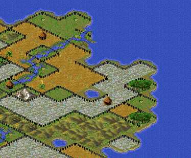
If you haven't seen Kull's thread about adding rivers yet... I got a little carried away with testing how the river-adding thing works, and later if I could posibly use this to add more terrains.
And then I found out a nice property of the dithering image. I don't know if it's been discovered before, but I thought it was nice enough to share...
Look here...
 Attachment: fence.jpg Attachment: fence.jpg
This has been downloaded 330 time(s).
Last edited by Mercator on 02-11-2002 at 03:55
|
|
| |
|
| |
|
Mercator
|
Sorekara no Nanimo
Jan 1970
time: 06:13
|
|
quote:
Originally posted by Kull
Doh. I musta swallowed an extra helping of stupid pills!
|

quote:
Changing that to other than black might solve the problem...... |
quote:
Hmmmm. I've never seen this done before |
It has been done... At least in one scenario by Heresson (Fading Lights, I think). No spectacular graphic or anything, but it has been done.
quote:
but suppose you created a semi-transparent gray fog graphic and placed it here? That way the unexplored map wouldn't be completely obscured in Black, but would reveal tantalizingly small glimpses of the underlying terrain, improvements, and cities (if present). |
I tried that out in ToT (I'm on the "wrong" computer again... That is, only ToT available, instead of both ToT and FW), and it certainly doesn't work there. You get the same funny effects as with making normal terrains (partially) transparent.
I thought I had tried it a long time ago with FW, but now I think of it, that was with the city radius graphic.
quote:
Thinking further about "Borders", it's clear that wouldn't work unless every civ had a single unique terrain type (not bloody likely!). |
It might work in highly alternative settings, with say, a more EU-like map (erm... I think, I don't have it myself), where terrain types wouldn't be of any importance. "Conquering" could be done by using engineers to transform terrain into "your" terrain type, while "regular" armies would be used to attack such "occupiers". The AI would be hopelessly lost, but with multiplayer it might work.
Perhaps the airbase graphic (altered) could also be used on all squares (since it can display the "owning civ), to show the difference between theoretical and de-facto borders.
( Wow! I might be on to something here) Wow! I might be on to something here)
|
|
| |
|
| |
|
Stefan Härtel
 |
Eddie's best friend
Jul 1999
time: 06:13
|
|
Hmm... coming back to the original post, this could be nice for a "zoo"-type scenario...    
But to drop my share of ideas, Maybe the changing of river-, road,- or railway graphic to a transparent veil could make a permanent fog...
But there's something else that troubles me a bit. It's a bug, but if someone has enough endurance, he could turn it into a feature.
Sometimes, in several scenarios (I remember encountering this rather often in SoG), where the map is mostly unexplored, between two of the player's turns, a part of the map suddenly becomes visible for a short moment. I think I can remember reading of other player's experiences with this. If someone can investigate this, it could make a nice "lightfire"-effect...
|
|
| |
|
Kull

|
El Paso, TX USA
Mar 1999
time: 22:13
|
|
quote:
Originally posted by Mercator
It's not a separate terrain type, since it's encoded entirely differently and separately in savegames. It's probably more something like:
code:
if (discovered) then display(terrain) else display(blank)
And then it's treated graphically the same as a land-type terrain (as can be seen from the coasts at map edges). |
I'm sure that's true. Nevertheless, the game treats the unexplored graphic EXACTLY as if it were a piece of terrain. If you were a designer, would you create an entirely different set of code to emulate something you've already coded? In this case, apparently not. I'll try to be more specific, so lets step through your "code example":
1) if (discovered) - Checks to see if units have been near. Pretty basic, but I'm still curious to see if there's a way to "shut off" this unit effect (but I digress)
2) then display(terrain) - Replaces the "unexplored" graphic with the underlying terrain graphic. Again, this makes sense.
3) else display(blank) - Here's where it gets interesting. In a nutshell, what IS "blank"? Sure, we know it's the black tile at "X" location of the Terrain1.gif file. But where is the information that represents this graphic? In other words, it's treated like terrain, so why wouldn't it be coded the same? There ARE some clear differences. For example, normal terrain would refer to the Rules.txt for food, shield, and movement vales. We know that's not the case with "unexplored". Still, isn't it possible that those values exist, except they are hard coded?
Maybe I'm wrong, but it sure would be nice to know the BASE LOCATION where information pertaining to "(blank)" resides, and exactly what values are coded there.
|
|
| |
|
|
GoPostal
|
I can see making this in my Bocage battle, thanks.
|
|
| |
All times are GMT. The time now is 05:13.
Apolyton Time is 00:13. |
top of page
|
| |
|
|
|
|

 |
Amazon
UK
|
Amazon
UK |
Amazon DE |
Amazon FR |
|
Amazon DE |
Amazon FR |





 . You'd have to find out for yourself.
 Attachment:


 Attachment: