|

|
el mencey
|
 |
España-UE-Canarias-Tenerife
Jun 2002
time: 05:23
|
|
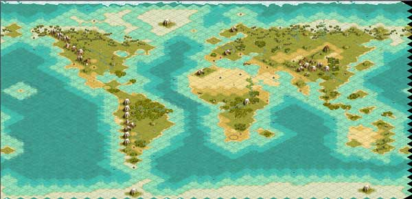
Earth Maps 60x60 Civ3 & PTW
 Attachment: tierra60gr.jpg Attachment: tierra60gr.jpg
This has been downloaded 219 time(s).
Last edited by el mencey on 27-11-2002 at 04:49
|
|
| |
|
| |
|
| |
|
| |
|
|
|
sabrewolf

|
 |
turicum, helvetistan
Jun 2002
time: 06:23
|
|
perfect sphere or not... diameter it varies by about 40 km, which is approx. 0.1% of the circumference, so basicly a sphere.
but you're right about that the maps shouldn't be 60x60, etc.
in fact, earth is 40'000 km around along the equator (dateborder to dateborder (you know... that virtual line between alaska and russia, going south through the pacific...) and but only 20'000 km "high" (pole to pole).
so maps ought to be 2:1 or even more, because we usually "cut" away the ocean masses north of cap noord and the cape down in the south of chile and the falkland islands.
but then again, world maps are always massivly "bent" and north america, europe and asia are expanded (up to 2.x times), while the equator is the only correct measured line.
but unfortunatly we can't have spherical maps in civ3 
anyhow... 120x120 (=7'200 tiles) or in proportional cases a 170x85 (=7'225 tiles) map... or neater, a 144x100 map (=7'200 tiles) would be great for my purposes 
|
|
| |
All times are GMT. The time now is 05:23.
Apolyton Time is 00:23. |
top of page
|
|
|
Forum Rules:
You may not post new threads
You may not post replies
You may not post attachments
You may not edit your posts
|
HTML code is ON
vB code is ON
Smilies are ON
[IMG] code is ON
|
|
|
|
|
|





 26-11-2002 04:28


 |
|