|
| |
|

|
Devil of Truth
|
 |
Keep honking... I'm reloading.
Sep 2002
time: 07:24
|
|
...or things that go "clump."
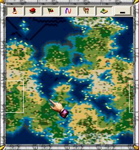
Don't you sometimes just hate the default CTP2 maps? They're so ordered, clumped and sometimes they're downright hideous. This SLIC script tries to address these glaring inconsistencies by adding a little bit of variety to most terrain types. For example: Those plains that span an entire continent may now have some hills and mountains or maybe some deserts or grasslands scattered about.
Have you ever wondered whether it is even geologically possible to have so many mountains in one hemisphere? The script also aims to enhance those mountain ranges that seem to stretch forever. For example: Instead of a solid wall of mountains stretching halfway across the map, you'll now find some grasslands or forests etc. scattered about between the mountains. Now you can actually build cities within mountain ranges.
Have you ever seen coral reefs anywhere on a standard CTP2 map? I haven't. This script will add some reefs too.
To rebuild a 140 x 280 (Gigantic) map took about 20 seconds on an AMD XP2200+, so you may be in for a wait. However, the script will only execute once, right at the start of a new game (it will not affect games in progress in any way), so all you need is a little patience.
To play god with your CTP2 maps, you need to:
1. Copy the SLIC file to the ...\ctp2_data\default\gamedata\ folder.
2. Add the line code:
#include "TerrainDiscombobulator.slc"
to the bottom of the script.slc file in ...\ctp2_data\default\gamedata\
3. Start a new game.
The code has been tested, and seems to work fine with the following:
Unmodded CTP2 - v1.11
Apolyton Pack - v1 & v2
Ages of Man – Alpha 2
Cradle – v1.3+
GoodMod – v1
MedMod – v2.2
World At War – v1.04
If you find any errors, or some strange things are happening to your maps, or have any suggestions, comments or complaints – please don’t hesitate to let me know.
(And all you experienced SLICers, don’t tell me this code is plain or easy – I know that already.)  
 Attachment: terraindiscombobulator.slc Attachment: terraindiscombobulator.slc
This has been downloaded 10 time(s).
|
|
| |
|
|
|
Maquiladora
|
|
The best way (i have found) to get your perfect spread of tiles, like fault lines and such, is to make specific rules in the tile file. So everytime a certain type of mountain appears you can make a mountain appear at any of the 8 directions around it, so it would eventually stretch into a fault line. Ive managed to iradicate the "swamp mass inside forest" effect with this method.
I havent tried this slic yet though...
|
|
| |
|
| |
|
| |
|
|
|
primemover
|
 |
Houston, TX, USA
Nov 2001
time: 23:24
|
|
quote:
Funny how unusual our planet is. On more then one of this planets 6 continents we find mountain ranges that are not at the edge. |
Ok... I was exaggerating a little to get a point across...
But not much... First, one must understand that when I say "coastal" I mean a few hundred miles inland, because there is always a zone of accretion between where the plate subducts and where the real folding occurs. This is still a good long ways from the center.
"Center" mtn ranges are generated by fractal altitude generators that naturally put mtn ranges at the center because they are the center of a high point on the generated topography.
In your explanation for central mountain ranges, you are for the most part correct:
quote:
The explanation for the three first cases is that they are the results of colliding continents. This however is irrelevant for CtP as it has no tectonic movement. |
But studying quite a bit of Geology in college, a continent-continent collision is the exception, rather than the rule. About the exceptions you mentioned:
The Ural Mts: This IS a continent-continent collision
The Himalayas: The other MAJOR continent-continent collision that exists.
The Rockies: are a different matter all together. Even today I would not say they are in the middle of the continent. But be that as it may, when they were created they were a coastal range, with the subducting plate trench only being 400-500 miles to the west (within normal parameters-- there is always SOME space in the form of an accretion ridge). At the same time, their creation was a bit different than typical mtn building. It was followed by the crustal extension that created the Nevada Basin and range etc... so the Rockies are still more or less a coastal range that has "moved" inland a bit due to post-creation-circumstances.
New Guinea? You are right about mountain ranges on large islands. New Guinea is an Island. New Guinea is the top of a new continent believed to be in the formation stages.
Ok... so yeah I am being a bit picky here...  and maybe to most people it wouldn't be so obvious, but to me it was painfully so and maybe to most people it wouldn't be so obvious, but to me it was painfully so  . Which lead me to the idea of the educational value of telling players why this was so... part of the great library (if we could change it?) or even a new game altogether using all these great ideas and changes. . Which lead me to the idea of the educational value of telling players why this was so... part of the great library (if we could change it?) or even a new game altogether using all these great ideas and changes.
Now that I have seen that the terrain can be altered... (I did not know this before) maybe a temporary solution is possible (but eventually it would be nice to have a scientifically consistent game)
|
|
| |
|
|
|
Devil of Truth
|
|
Keep honking... I'm reloading.
Sep 2002
time: 07:24
|
|
Wow! This thread turned intellectual fast! Very interesting reading. 
quote:
Originally posted by SMIFFGIG
ok ive downloaded and tested the mod, and generally its quite good afew things though
1. Plains-glacier-grassland=glacier=plains-glacier. Isn very realistic, or not in the abundance in which it appeared on my last map
2. Kelp and coral maybe a little to abundant
3. The GIGANTIC masses of swamp clusters are unrealistic and annoying (on the last map there was screenfulls of the stuff
4. Maybe not quite enought Plains grassland
5. Maybe a little to much forest
6. A nice addition would be if you could get mountains to appear in lines as well as clumps (like fault lines)
7. Another nice addtion would be to have more and better spread smaller islands around the map
8. Finally i have to say, this mod has great potential |
SMIFFGIG:
1. The ratio of glaciers, tundra, plains and grassland is very unrealistic. It is easy to correct, but I made it like this on purpose. Cold tiles are fairly useless (relative to others) and even though I didn’t want to eliminate them entirely I did want to reduce their impact.
2. I haven’t increased or decreased the profusion of kelp, however, if enough people agree that there is too much, I can easily make some go away. I agree on the coral though.
3. My code doesn’t deal with swamps. The map settings I usually use (Cradle 1.3+; default sliders) doesn’t produce any swamp problems, but I can easily generate code to take care of this if you’d like.
4. More plains and grasslands? Are you saying my code takes too much away, or do you just want the code to create more?
5. I’ll look into it.
6. This would be nice. I don’t like the clumps and as primemover et al has pointed out, it’s not very realistic. My code doesn’t really create mountain chains, it just breaks them apart. Creating code to actually form chains would be a lot more challenging, but far from impossible. I’ll look into it.
7. The code doesn’t touch landmasses.
8. Thanks.
quote:
Originally posted by Maquiladora
The best way (i have found) to get your perfect spread of tiles, like fault lines and such, is to make specific rules in the tile file. So everytime a certain type of mountain appears you can make a mountain appear at any of the 8 directions around it, so it would eventually stretch into a fault line. Ive managed to iradicate the "swamp mass inside forest" effect with this method. |
Maq:
Your solution sounds so much better than SLIC. If you don’t mind, I’d love to have an example please. 
Thanks everybody for your support and interest (and geography lessons  ). Keep those suggestions coming. I’ll post an update soon. ). Keep those suggestions coming. I’ll post an update soon.
|
|
| |
|
|
|
Maquiladora
|
|
quote:
Originally posted by Devil of Truth
Maq:
Your solution sounds so much better than SLIC. If you don’t mind, I’d love to have an example please. |
An example? Well i could tell you to use Tile View, its pretty easy to understand what each tile rule means from the readme, you can edit the existing ones and add new rules too.
What i havent figured out is if you define 2 rules for the same specific tile, say, a beach tile on the east, then i dont know if it uses each rule at random, or the first one in the whole tile file for that particular east beach tile.
You could actually create lots of rules that make the whole lot of tiles fit into a perfectly realistic geological jigsaw, but that would take away alot of the randomness from the map generator and youd probably just get the same clump of land with water around each, like Civ3
One of CtP2's advantages, theres so many terrain types, but that of course makes it harder to get every one in the right place.
So basically i cant really give an example 
I remember Peter Triggs made a script for the map generator too, somewhere...
|
|
| |
|
| |
|
|
|
Maquiladora
|
|
quote:
Originally posted by primemover
I'm wondering if it is possible... with terrain improvement slic... to make more (even a whole new basic terrain type?) |
I read somewhere on this forum from a programmer on CtP2, that you can only have a maximum of the 24 terrain types already there. But ive seen the generator use the bridge tile and the little huts from the tile file in the Magnificent Samurai scenario.
I havent tried basically but it certainly looks promising.
quote:
PS... who is Peter Triggs and what has he done with map generation? (was it for CTP2?) |
Peter wrote a small script to change all the pretty useless tiles at the start of the game, to ones that are useful for gameplay. So it would change swamp to grassland or plains, stuff like that.
|
|
| |
|
|
|
LDiCesare
|
|
La Ferté sous Jouarre France
Jan 2001
time: 05:24
|
|
quote:
I recently discovered that the writers of "Clash of Civilizations" (an alternate civ on apolyton) are trying to create a map generator to do something of what I had in mind for my own. We might ask them... if we try an external map generator. But I don't think theirs is finished yet either. |
It definitely is not.
(edit) There is an altitude only map generator, which gives small maps and is not very efficient IMO (/edit)
You would probably have problems converting it to CtP2 anyway because we want to have different data dor elevation (hills/mountains/plains) and vegetation (woods on hills). Though CtP2 has hills/desert hills, the representation of the data would be hard to translate. Also, rivers are going to be on-edges and not in-square, so that makes a difference too.
Any comments in the relevant thread (http://apolyton.net/forums/showthre...877#post1529727) are approeciated. You will also find some links there to previous models and some map generator programs (have to follow some links, though).
Note that if we get a map generator program working for Clash that would suit you, the resulting file is a quite simple format, and I could explain it to you if needed.
Last edited by LDiCesare on 12-12-2002 at 14:49
|
|
| |
|
|
|
finfahey
|
|
Quick dirty suggestion...
I really like the idea of alternate map generation systems. But that's the kind of thing that you go into and never emerge from - OTOH to make the map more interesting, why not take a leaf out of SMAC and 'overstamp' the map with SLIC routines putting blocks of terrain and/or goods in random places once the main generation is finished?
So, just as SMAC has stuff like Uranium Flats and the New Sargasso, you could have the Sea of Whales or the Emerald Mountains. The thing is balance and restraint - you want to invent lots of enriched terrain areas, but any given game would only include, say, a third/half of them. This adds big fun to exploration for a start.
The other feed-in is that it gives you, or your opponents, areas to covet and fight for. This feeds into the Civ3 thing about strategic goods.
e.g Invent block feature called 'Oil Lake' - have it turn up in the most (already) conflict-ridden part of the planet and you've got some of our geopolitics right there (but in ctp2 it might just turn up somewhere unnoticed to that time, has to be desert, though).
And you don't have to dump the goods into the area until one of the players gets the requisite advance, so that's a well Civ3-type thing.
Just a pity that the names can't appear on the map a la SMAC. Hey, I might have a go at this, though - could be fun making up these map features.
|
|
| |
All times are GMT. The time now is 05:24.
Apolyton Time is 00:24. |
top of page
|
| archivepost |
|
Forum Rules:
You may not post new threads
You may not post replies
You may not post attachments
You may not edit your posts
|
HTML code is ON
vB code is ON
Smilies are ON
[IMG] code is ON
|
|
|
|
|
|





 06-12-2002 14:22





 . (Which makes perfect sense.)


 Attachment:
  |
|