Apolyton Archive  |  Preserved copy of the Apolyton Civilization Site and its forums as they stood in September 2005. Read-only; nothing here can be posted to or replied to.  |  Forum index |  About this archive |  The 1998–2001 UBB forums
Today on Apolyton WARDELL INTERVIEW PROMO A.C.S. HISTORY CHAPTER 4 GET CIV4 /w FREE PLUS! A.C.S. PHOTO GALLERY GET A.O.M. V1.1
Apolyton Civilization Forums
main| civ2| civ3| civ4| smac| ctp2| ron| moo3| galciv| galciv2| alt| about|
ApolytonPLUS | register | search | faq | new posts | pm (-/-) | upload | members
hall of fame new! | civgroups | civgroups news | interviews | the column | radio | chat | directory | news | store | PLUS
Apolyton Civilization Forums : Powered by vBulletin version 2.0.3 Apolyton Civilization Forums > Civilization III > Civ3-Files > MAP: Earth120X180 12players
Show a Printable Version | Email This Page to Someone! | Receive updates to this thread | Report this to Apolyton news!
16.Sep: 7 NEW FILES
15.Sep: TRIAL + NO SLEEP = ONE GAME
13.Sep: PATCH THE PREVIOUSLY UNPATCHABLE

bottom of page
   - CIV3 CONQUESTS $29.99 - CIV3 from $9.99
Author
Thread    < Last Thread     Next Thread > Post New Thread     Post A Reply
Becephalus is offline Becephalus
Settler

Dec 2002
time: 05:24
  Old Post 30-12-2002 02:11
Edit/Delete Message Reply w/Quote
#1 Report this post to a moderator
Earth120X180 12players Support Apolyton buy from Amazon

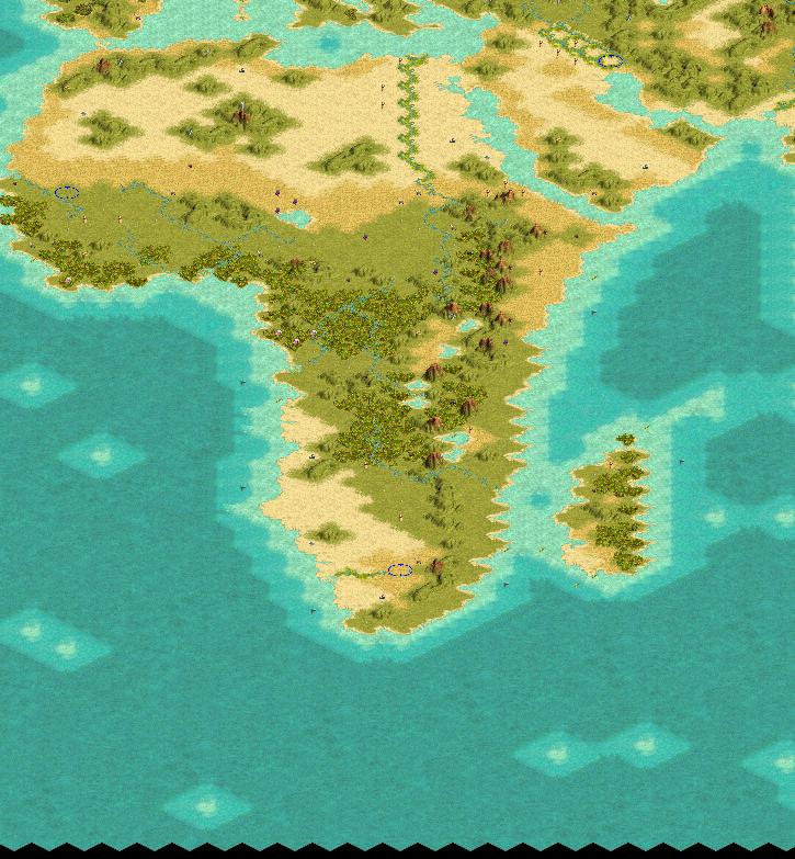
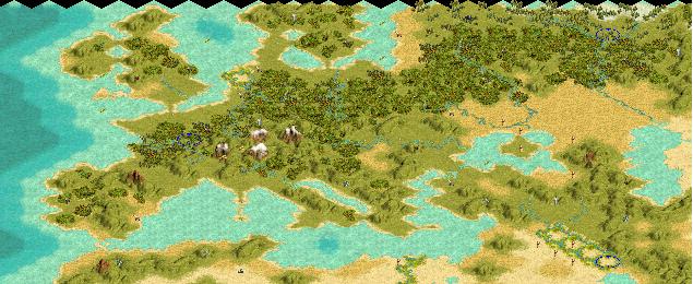
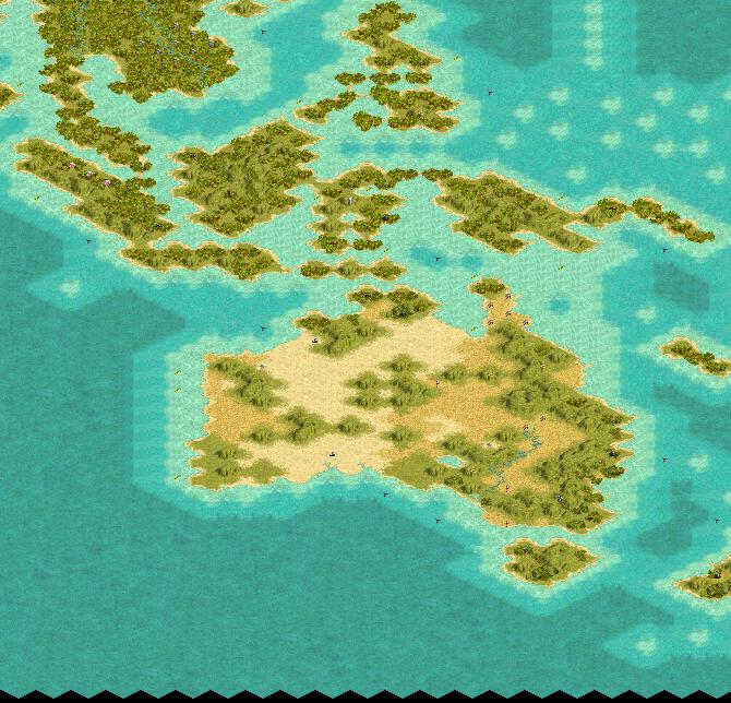
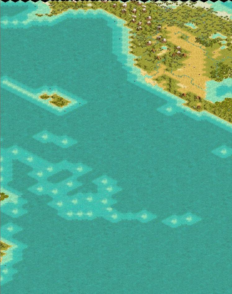
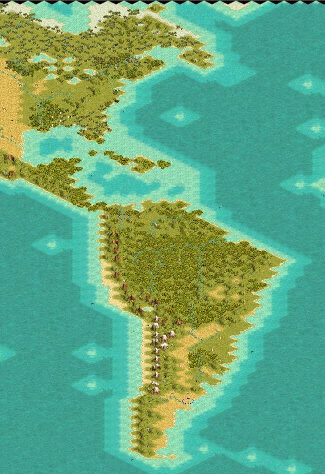
This map is an attempt to render an accurate earth map with as little distortion as possible. This was done by using a mercator-like projection and cuting off the top and bottom at 60* lattitude (roughly the artic and antartic circle). This has two benefits...as stated above it reduces distortion greatly, and two it prevents massive artic empires in northern Russia and Canada...those of you who play against cpus on most earth maps know what I am talking about

I do not think this takes much from the play either as these regions are pretty historically unimportant in civilization terms

Also I made most small islands costal squares...this allows one to use them for exploration with galleys and caravels but saves one from having 50 disproportionately large islands all over the map (and now you do not have to wait for marines to take all those stupid little things from the ever expanding cpus) so every island which would be just one square was either connected together with other nearby island or eliminated

I am a geography and mathmatics major and went to length to attempt to make the map accurate to 4000bc...obviously there are lots of comprimises to be made because of the large tiles...playability and accuracy also conflict often and I tried to chose accuracy

I have one version of the map with all civs at right strating locations and one where there are 12 more or less equally valuable/viable and equally spaced starting locations (4 in americas 8 in eurasiafrica)

The resources are just randomly distributed...I did this for two reasons...first much resource production is a matter of historical happenstance (e.g. brazil has just as much mineral wealth as russia or the us it just does not have the capital/infrastructure to exploit it)...secondly I view the resources in civ3 as proxies...so oil is more like "energy" and horses are "ridable beasts" etc. This makes some sense with the strategic resources and perfect sense with luxery resources since their selection/distibution is ure historical happenstance

If there is enough interest I might do an accurate resource map,but the research for that is a lot of work

Please give me feedback as I am still working on this and would greatly appreciate any comments positive or negative...

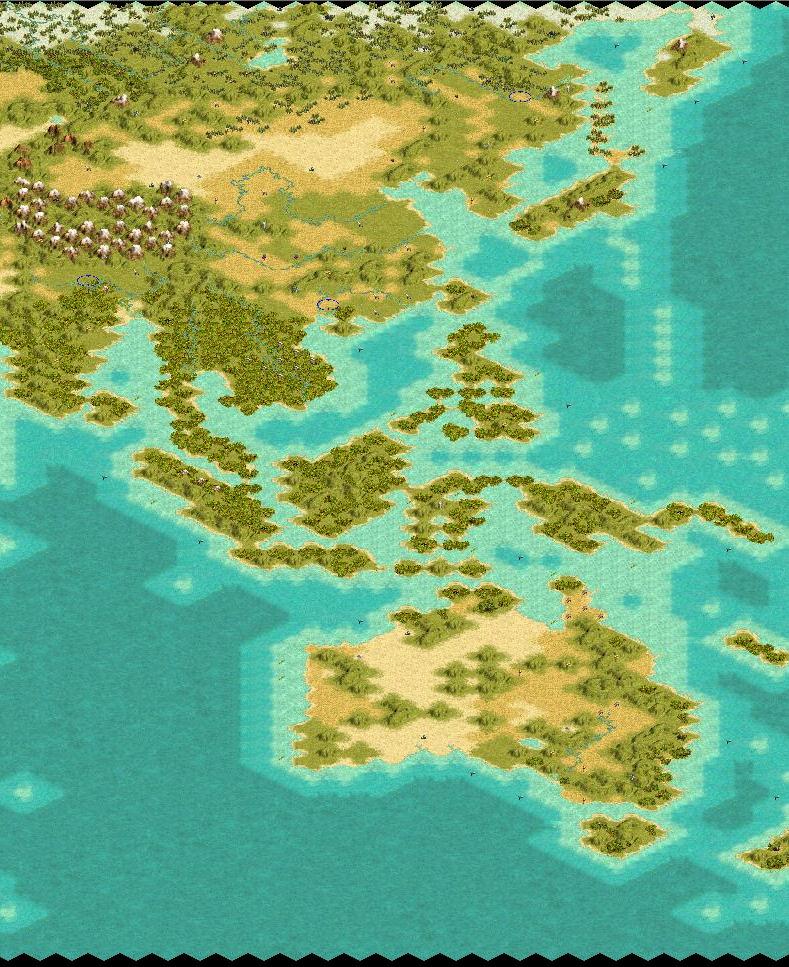
India and Indochina still need some work but I have not been able to get them in a configuration I like

Becephalus is offline Becephalus
Settler

Dec 2002
time: 05:24
  Old Post 30-12-2002 02:17
Edit/Delete Message Reply w/Quote
#2 Report this post to a moderator
Support Apolyton buy from Amazon

hmmm...how do you get screenshots of your maps....

Becephalus is offline Becephalus
Settler

Dec 2002
time: 05:24
  Old Post 30-12-2002 03:02
Edit/Delete Message Reply w/Quote
#3 Report this post to a moderator
Enter the AD-FREE zone

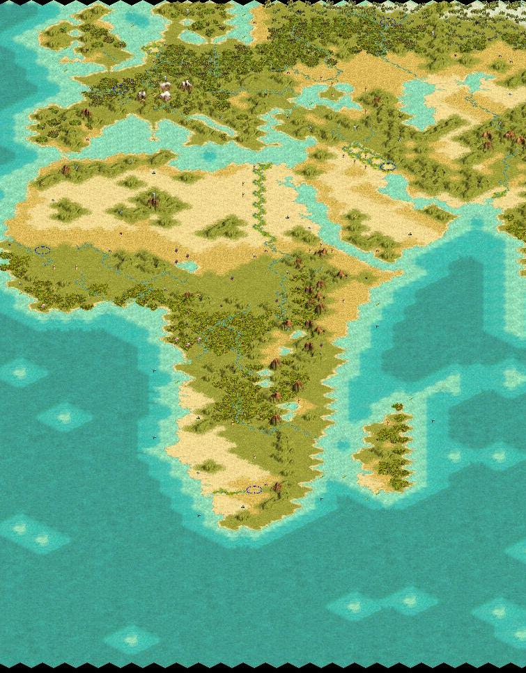
ok i fugured it out

Attachment: africa.jpg
This has been downloaded 188 time(s).

Becephalus is offline Becephalus
Settler

Dec 2002
time: 05:24
  Old Post 30-12-2002 03:03
Edit/Delete Message Reply w/Quote
#4 Report this post to a moderator
Suffering from ads?

asia

Attachment: europe.jpg
This has been downloaded 185 time(s).

Becephalus is offline Becephalus
Settler

Dec 2002
time: 05:24
  Old Post 30-12-2002 03:06
Edit/Delete Message Reply w/Quote
#5 Report this post to a moderator
Support Apolyton buy from Amazon

oceania

Attachment: oceania.jpg
This has been downloaded 180 time(s).

Becephalus is offline Becephalus
Settler

Dec 2002
time: 05:24
  Old Post 30-12-2002 03:17
Edit/Delete Message Reply w/Quote
#6 Report this post to a moderator
Support Apolyton, buy Civilization III: Complete

1 of 4

Attachment: 1of4.jpg
This has been downloaded 177 time(s).

Becephalus is offline Becephalus
Settler

Dec 2002
time: 05:24
  Old Post 30-12-2002 03:17
Edit/Delete Message Reply w/Quote
#7 Report this post to a moderator
Avatar Enlargement: We've got the solution

2of4

Attachment: 2of4.jpg
This has been downloaded 176 time(s).

Becephalus is offline Becephalus
Settler

Dec 2002
time: 05:24
  Old Post 30-12-2002 03:18
Edit/Delete Message Reply w/Quote
#8 Report this post to a moderator
Support Apolyton, pre-order Civilization IV

3of4

Attachment: 3of4.jpg
This has been downloaded 177 time(s).

Becephalus is offline Becephalus
Settler

Dec 2002
time: 05:24
  Old Post 30-12-2002 03:19
Edit/Delete Message Reply w/Quote
#9 Report this post to a moderator
Support Apolyton, buy Call to Power 2

4of4

Attachment: 4of4.jpg
This has been downloaded 178 time(s).

Kal-el is offline Kal-el
Warlord

Jan 2002
time: 21:24
  Old Post 30-12-2002 09:53 Visit Kal-el's homepage!
Edit/Delete Message Reply w/Quote
#10 Report this post to a moderator
Support Apolyton, buy Alpha Centauri

Ok man, you asked me for my opinion. I like the general idea behind the map, cutting off the poles to try and reduce distortion, but then my use Mercator? Mercator is a notoriously bad projection. That being said, here are a few questions for you.

-Why is the Iberian Peninsula connected to North Africa?

-Why is Italy connected to Greece?

-Why is England connected to France?

-Why is Sweden is attached to Germany and Denmark?

-Why is Iran is attached to Saudi Arabia?

-Why is Borneo is attached to Celebes?

-Why is Japan is attached to the Sakhalin Islands?

-Why is there no Baja California?

Becephalus is offline Becephalus
Settler

Dec 2002
time: 05:24
  Old Post 30-12-2002 11:23
Edit/Delete Message Reply w/Quote
#11 Report this post to a moderator
Increase the size of your Attachments

1) I used the mercator because that is what almost all vegetation elevation andclimate maps are done on and that is what I am using to decide what terrain where

2)Because the straits have historically been crosssed in small craft and one has no need of a actually naval ship to cross them

3)This is the same story for all of these places...I would rather have the map acurately portray land then worry about 20mile wide (or less) straits being closed off...the resolution on a map like this is around 100 to 150 miles on a side per tile...100 to 150 miles that is right...so how would you represent a 20mile wide strait?...by 150mile wide strait or by no straight at all?...plus all those straits you mention are still navigable by ship you can just cross diagonally. I think a diagonal connection with the land more acurately represents the fuctionality of the landofrms in those regions anyways...I one wants to isolate england like was done historically one need only build a fortress and throw a defensive unit in there

4) to make those straits completely uncrossable I would have to get rid of normandy and ille de france or all of southeast england...or grenada and cadiz or tangiers etc you get the picture...

Becephalus is offline Becephalus
Settler

Dec 2002
time: 05:24
  Old Post 30-12-2002 11:35
Edit/Delete Message Reply w/Quote
#12 Report this post to a moderator
Support Apolyton, buy Civilization: The Boardgame

that first point actually should be qualified as many of them are also robinson...but discontinuois maps (especially when thee is no grid overlay can be hard to poject onto a rectangle) Plus although the mercator is notoriously bad it is mostly thought to be so becaquse of the gross distortion of the extreme north...what better way to eliminate distortion than to pick a map that focuses most of its distortion in one area and then not include that area?

sabrewolf is offline sabrewolf

Emperor
turicum, helvetistan
Jun 2002
time: 06:24
  Old Post 31-12-2002 04:32 Visit sabrewolf<br><a href=/members><img src=/forums/images/supporter-icon.gif border=0></a><BR>'s homepage!
Edit/Delete Message Reply w/Quote
#13 Report this post to a moderator
Remove this text

i get your point but kind of disagree. one of the reasons that conquering britain in earlier eras was difficult is because it's an island.

also, why a D-Day in normandy if you could just march past dover and stand on the european continent

seafaring was extremely dangerous and not many rafts and primitive boats made it over even short passages like the street of gibraltar or the channel. only when "proper" ships were invented (represented by galleys in civ3), a bigger number of people could cross these areas...

don't forget, these are VERY early days (map maping comes iirc with writing... and that's been around for well over 5000 years...)

i think denmark-sweder is the only thing which is realistic. afaik you can SEE sweden from one of the danish islands... and they are just spitdistances away from each other (exadurated ofcourse )

Becephalus is offline Becephalus
Settler

Dec 2002
time: 05:24
  Old Post 03-01-2003 02:56
Edit/Delete Message Reply w/Quote
#14 Report this post to a moderator
Support Apolyton buy from Amazon

you can see england from france and vis a vis i am pretty sure it is the same with gibraltar etc.

Gangerolf is offline Gangerolf
Prince
huuhh
May 2001
time: 06:24
  Old Post 10-01-2003 16:45
Edit/Delete Message Reply w/Quote
#15 Report this post to a moderator
Suffering from ads?

quote:
i think denmark-sweder is the only thing which is realistic. afaik you can SEE sweden from one of the danish islands... and they are just spitdistances away from each other (exadurated ofcourse )


yeah but you can't sail into the baltic sea...

Gangerolf is offline Gangerolf
Prince
huuhh
May 2001
time: 06:24
  Old Post 10-01-2003 16:47
Edit/Delete Message Reply w/Quote
#16 Report this post to a moderator
Browse Apolyton AD-FREE

nor can you go from the mediterranean to the atlantic without building a canal city. that should be fixed IMO

Kal-el is offline Kal-el
Warlord

Jan 2002
time: 21:24
  Old Post 10-01-2003 23:21 Visit Kal-el's homepage!
Edit/Delete Message Reply w/Quote
#17 Report this post to a moderator
Got spare money?

That is my biggest problem with all these connections. You can't sail into or out of large bodies of water that you should be able to. That and it reduces the significance of an island nation's isolation.

If you look you can find other projections with all that information that you are looking for. Or conversely you could just use the more shape accurate projections to develop your land masses and then use the other info maps to fill in the details.

Becephalus is offline Becephalus
Settler

Dec 2002
time: 05:24
  Old Post 14-01-2003 11:29
Edit/Delete Message Reply w/Quote
#18 Report this post to a moderator
Support Apolyton, buy Civilization 2

well i changed the map so borneo does not connect to celebs, japan to the karatato islands, gibraltar to tangiers, calais to dover, copenhagen to sewden and sweden to germany...this makes some of these places look goofy but on both sites i posted this map people really did not like these connections Thanks for the input and have a good day

Attachment: earth120x180.zip
This has been downloaded 9 time(s).

Gramphos is offline Gramphos
ACS Civ III Files Manager, Prince of Development
Chalmers, Sweden
Apr 2001
time: 06:24
  Old Post 18-01-2003 05:22
Edit/Delete Message Reply w/Quote
#19 Report this post to a moderator
Help yourself to an AD-FREE life

Yuo should link the file to the first post.

  < Last Thread     Next Thread > Post New Thread     Post A Reply
All times are GMT. The time now is 05:24.
Apolyton Time is 00:24.
    top of page
Rate This Thread:
Forum Jump:
Forum Rules:
You may not post new threads
You may not post replies
You may not post attachments
You may not edit your posts
HTML code is ON
vB code is ON
Smilies are ON
[IMG] code is ON


Contact Us - Apolyton Civilization Site - Support Us!

Building a better Apolyton through better information. Click here and take our poll!
Non-US visitors, click here!

Powered by: vBulletin Version 2.0.3
Copyright ©2000, 2001, Jelsoft Enterprises Limited.

Page generated in 0.0472 seconds (88.91% PHP - 11.09% MySQL) with 30 queries
Page Loading Time:

Support Apolyton: Amazon USA | Amazon UK | Amazon DE | Amazon FR |
Support Apolyton and get FREE PLUS, Buy from Chips&Bits: Galactic Civilizations | Galactic Civilizations: Deluxe Edition | Call to Power 2 | Civilization: The Boardgame | GURPS/ Alpha Centauri | Alpha Centauri | Civilization IV | Civilization III: Complete |


Front Page | Civilization IV | Civilization III | Civilization II | Call to Power II | Alpha Centauri | Master of Orion III
Rise of Nations | Galactic Civilizations | Galactic Civilizations II | Misc
Alt.Civs | Civ I | C:CtP I | About | News | Directory | Apolyton Store | Forums | Chat | Columns | Interviews | Newsletter
Scenario League | CSC | Clash of Civs | Spanish Site | CtP Maps | Cradle of Civ | WesW's Ctp1/2 Site | Civ3 Haven

apolyton.net | apolyton.com | civilization2.net | civilization3.net | civilization4.net | civilizationiv.info | calltopower.net | galciv.net | galciv2.net | moo3.net