 |

|
argha
|
|
I was prob a little hasty in my placement, but there is definitely one that is south of eye of the storm, so by counting 7 or 8 cities all told
|
|
| |
|
|
|
Beta

|
 |
Prowling in a PBEM near you!
Nov 2002
time: 00:27
|
|
Argha - n/p. I was suspecting they have 10-11. maybe even 12 cities. I think there must be more decent land south than they are letting on.
I went looking for this piece again - trying to remember where I put it. As this looks like the official GS city site thread - I will post it here.
From an earlier PM from nbarclay of GS:
In regard to your interest in the geography of South Estonia, Tim is on the north end of what we call the Spinebreaker Mountains and Willy has entered what we call the Desert of Tears. Waters from the Spinebreaker Mountains come together to form a river we call the Flood of Tears, which borders the western edge of the desert. (By the way, we may someday be able to arrange an irrigation project to your lands if you are completely without fresh water for irrigation. Of course the scale of such a project is far beyond what would be practical until our nations are larger and more prosperous.)
South of the desert is a band of plains generally two tiles from north to south. Eye of the Storm is founded as the River of Tears enters this band, and has the mixed blessing of access to flood plains that may help it grow or die as the Generator of Fortune sees fit. Our second city, Hurricane, overlaps our capital next to where the river empties into the ocean. South of the plains, as the land narrows toward its southern tip, we have a region of grassland small enough that a single city could cover more than two thirds of it (although good use of coast can stretch its use farther).
On the western side of the continent, Tim has seen essentially all of the grasslands and forests that the area he is in has to offer. The rest is almost all hills, mountains, and a coastal desert, until a few tiles south of Willy’s latitude where the strip of plains reaches that coast. At its widest, the land stretches less than a tile west of what Tim has seen, and the land narrows to the south before reaching the band of plains.
We hope your cartographers can make good use of this description in developing at least a rough sketch of South Estonia. It is only too bad they do not yet have the skill to develop true maps.
|
|
| |
|
|
|
argha
|
|
Too bad we could not trade for a territory map
|
|
| |
All times are GMT. The time now is 05:27.
Apolyton Time is 00:27. |
top of page
|
|
|
Forum Rules:
You may not post new threads
You may not post replies
You may not post attachments
You may not edit your posts
|
HTML code is ON
vB code is ON
Smilies are ON
[IMG] code is ON
|
|
|
|
|
|






 08-04-2003 20:45


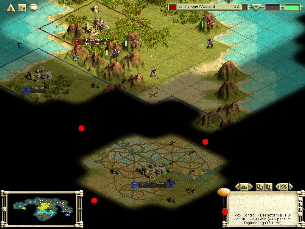


 .. but I think the 7-7-7 city is 8 one tile. When it first went in - it was fairly clear from the cultural border that the city is just south of that last mountain we can see.
 |
|