Apolyton Archive  |  Preserved copy of the Apolyton Civilization Site and its forums as they stood in September 2005. Read-only; nothing here can be posted to or replied to.  |  Forum index |  About this archive |  The 1998–2001 UBB forums
Today on Apolyton WARDELL INTERVIEW PROMO A.C.S. HISTORY CHAPTER 4 GET CIV4 /w FREE PLUS! A.C.S. PHOTO GALLERY GET A.O.M. V1.1
Apolyton Civilization Forums
main| civ2| civ3| civ4| smac| ctp2| ron| moo3| galciv| galciv2| alt| about|
ApolytonPLUS | register | search | faq | new posts | pm (-/-) | upload | members
hall of fame new! | civgroups | civgroups news | interviews | the column | radio | chat | directory | news | store | PLUS
Apolyton Civilization Forums : Powered by vBulletin version 2.0.3 Apolyton Civilization Forums > Civilization III > Civ3-Files > MAP: Earth map 120x120
Show a Printable Version | Email This Page to Someone! | Receive updates to this thread | Report this to Apolyton news!
16.Sep: 7 NEW FILES
15.Sep: TRIAL + NO SLEEP = ONE GAME
13.Sep: PATCH THE PREVIOUSLY UNPATCHABLE

bottom of page
   - CIV3 CONQUESTS $29.99 - CIV3 from $9.99
Author
Thread    < Last Thread     Next Thread > Post New Thread     Post A Reply
el mencey is offline el mencey
Emperor
España-UE-Canarias-Tenerife
Jun 2002
time: 05:28
  Old Post 03-06-2003 22:52 Visit el mencey's homepage!
Edit/Delete Message Reply w/Quote
#1 Report this post to a moderator
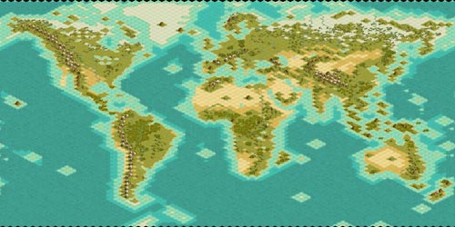
Earth map 120x120 Increase Your PM Length

File name: tierra120.bic tierra120.bix tierra120rr.bic and tierra120rr.bix
rr=random resource.
Civilization III and Play The World Maps.
Size 120x120
File size: 78 and 80Kb (Zip format).
Creation method: to pulse. +- 9h.
Number of recommended civilizations: 5-6
Version: 1.0
Date: 3 Jun 2003
------------------------------------------------------------------------
You do not need permission to use my maps for scenarios, but if to put credit, please.

Attachment: tierra120_l.jpg
This has been downloaded 267 time(s).

el mencey is offline el mencey
Emperor
España-UE-Canarias-Tenerife
Jun 2002
time: 05:28
  Old Post 03-06-2003 22:54 Visit el mencey's homepage!
Edit/Delete Message Reply w/Quote
#2 Report this post to a moderator
Support Apolyton, buy Call to Power 2

bic file

Attachment: tierra120_mencey.zip
This has been downloaded 39 time(s).

el mencey is offline el mencey
Emperor
España-UE-Canarias-Tenerife
Jun 2002
time: 05:28
  Old Post 03-06-2003 22:54 Visit el mencey's homepage!
Edit/Delete Message Reply w/Quote
#3 Report this post to a moderator
Full PM-box? Change here!

bix file

Attachment: tierra120_mencey_bix.zip
This has been downloaded 33 time(s).

sabrewolf is offline sabrewolf

Emperor
turicum, helvetistan
Jun 2002
time: 06:28
  Old Post 08-06-2003 14:23 Visit sabrewolf<br><a href=/members><img src=/forums/images/supporter-icon.gif border=0></a><BR>'s homepage!
Edit/Delete Message Reply w/Quote
#4 Report this post to a moderator
Enter the AD-FREE zone

perfect size!!!

can i request a world map 160x80 or 140x70 (after all, the circumference of the earth is the double of pole to pole).
the minimap will look strange (it's already scaled down in the vertical axis), but the experience will be more reallife...

gracias!

TheRockit is offline TheRockit
Settler
Bossier City, La.
Jun 2003
time: 23:28
  Old Post 30-06-2003 10:13
Edit/Delete Message Reply w/Quote
#5 Report this post to a moderator
Earths circumference... Inflate your Upload Space

Actually the circumference of the Earth around the equator is ~24,904 miles and the POLAR circumference is ~24,860 miles.

There is a bulging of the circumference at the equator which excludes the planet from being a perfect sphere but it is not so great as to be double that of the poles.

If you were to scale it thusly then the sizes would be 160x159 and 140x139 or so... rounding in favor of the bulge that is!

Wernazuma III is offline Wernazuma III
Emperor
Decolonize!
Aug 2000
time: 06:28
  Old Post 01-07-2003 21:16 Visit Wernazuma III's homepage!
Edit/Delete Message Reply w/Quote
#6 Report this post to a moderator
Support Apolyton, buy Civilization III: Complete

But that distorts the proportion on a world map towards the poles too much. After all a single dot (the pole) will extend all the way from the west to the east on the map...
I'm currently working on a huge 260x160 earth map, but it's still in its initial phase:

Attachment: preview.jpg
This has been downloaded 123 time(s).

TheRockit is offline TheRockit
Settler
Bossier City, La.
Jun 2003
time: 23:28
  Old Post 02-07-2003 02:47
Edit/Delete Message Reply w/Quote
#7 Report this post to a moderator
Support Apolyton buy from Amazon

One thing you could try, it would probably look 'wonkity' though... Take a true projection with minimum distortion of each continent INDIVIDUALLY and then scale that to the map. Place them in scale distances to each other and see what weirdness happens. That way each continent is sized and shaped properly by itself and then laid down on a flat surface as best possible. Unfortunately the continents are not flat and so we still have problems!!!

And of course you would (if trying the above for fun) need to make sure each is in the same scale or sizing issues will corrupt the result.

Wernazuma III is offline Wernazuma III
Emperor
Decolonize!
Aug 2000
time: 06:28
  Old Post 02-07-2003 22:24 Visit Wernazuma III's homepage!
Edit/Delete Message Reply w/Quote
#8 Report this post to a moderator
Support Apolyton, pre-order Civilization IV

I need a larger Europe anyway. In my current try, Italy looks so messsed up, I can't stand it. Europe is simply too complex for Civ world maps, even for 260x160, when it is put in the same scale as the other continents.

TheRockit is offline TheRockit
Settler
Bossier City, La.
Jun 2003
time: 23:28
  Old Post 03-07-2003 06:31
Edit/Delete Message Reply w/Quote
#9 Report this post to a moderator
Increase the size of your Attachments

An interesting thing to me is how such precise detail is applied to geographic feature in Europe but fudged or lost in Asia and N.America... well any other continent that is I suppose.
We can all say that some geographic location near or interesting to us is 'out of sorts' when another location on a map with a feature of similar size is very well done.
It is very tough to be universally fair and accurate when making a map to represent a dynamic living sphere with isometric squares in a two dimensional layout!

Wernazuma III is offline Wernazuma III
Emperor
Decolonize!
Aug 2000
time: 06:28
  Old Post 03-07-2003 21:57 Visit Wernazuma III's homepage!
Edit/Delete Message Reply w/Quote
#10 Report this post to a moderator
Increase the size of your Attachments

quote:
Originally posted by TheRockit
An interesting thing to me is how such precise detail is applied to geographic feature in Europe but fudged or lost in Asia and N.America... well any other continent that is I suppose.
We can all say that some geographic location near or interesting to us is 'out of sorts' when another location on a map with a feature of similar size is very well done.
It is very tough to be universally fair and accurate when making a map to represent a dynamic living sphere with isometric squares in a two dimensional layout!


Well, I try to be most accurate with the other continents too, and actually it proved quite difficult to do so as well for the Caribbean, mainly all landmasses with many islands and peninsulas. Yet with Europe there's that other problem that lots of civs are starting there, so it's the very heartland of several civs. While my Baja California might be even less accurate than Italy, it's a fringe compared to Italy. I'll try no size up Europe just a tad, so it doesn't look distorted compared to the others but that I gain a few tiles. Maybe I can do that by also stretching West Africa a few tiles.

TheRockit is offline TheRockit
Settler
Bossier City, La.
Jun 2003
time: 23:28
  Old Post 04-07-2003 06:23
Edit/Delete Message Reply w/Quote
#11 Report this post to a moderator
Remove this text

Isn't it a shame that there is so much desert and tundra and other 'barren' terrain endlessly stretching on in this world when perfectly fine places such as Italy, Ireland, Malaysia and the North American eastern seabord have to settle with a half dozen meager squares each or so? Hahah! Well there is always another option...

You can make a map which is in scale but oriented with the best layout of geography for each continent. Get the 'flatest' and most accurate map of each area, scale them appropriately and then make each continent as if it were a separate map but all on one larger board.

I think the key is that the really BIG maps do very well at portraying the Earth when proper details are considered but they are really big maps.

sabrewolf is offline sabrewolf

Emperor
turicum, helvetistan
Jun 2002
time: 06:28
  Old Post 13-07-2003 17:42 Visit sabrewolf<br><a href=/members><img src=/forums/images/supporter-icon.gif border=0></a><BR>'s homepage!
Edit/Delete Message Reply w/Quote
#12 Report this post to a moderator
Re: Earths circumference... Support Apolyton, buy Call to Power 2

quote:
Originally posted by TheRockit
Actually the circumference of the Earth around the equator is ~24,904 miles and the POLAR circumference is ~24,860 miles.

There is a bulging of the circumference at the equator which excludes the planet from being a perfect sphere but it is not so great as to be double that of the poles.

If you were to scale it thusly then the sizes would be 160x159 and 140x139 or so... rounding in favor of the bulge that is!


sorry i didn't reply earlier. forgot to subscribe to this thread.

you're right about the circumferences. but a map is a cut open and streched sphere.
the polar circumference is completely unimportant because you divide it into front and backside.
(god, difficult to explain what i mean)
you need ~12400miles (~20'000km) to get from the north to the south pole (from top to bottom of the map)
but you need the whole circumference (~24900miles, ~40'000km) to get from the left to the right end of the map.

do you understand what i mean?

the civ3-maps only look realistic, because the minimap viewer squashes the vertical axis. so it looks like a 2:1 format, but still is a 1:1 format in the game.

Kuciwalker is offline Kuciwalker
Emperor
of Schmooism
Feb 2001
time: 00:28
  Old Post 13-07-2003 19:58
Edit/Delete Message Reply w/Quote
#13 Report this post to a moderator
Re: Earths circumference... Put an end to popups!

quote:
Originally posted by TheRockit
Actually the circumference of the Earth around the equator is ~24,904 miles and the POLAR circumference is ~24,860 miles.

There is a bulging of the circumference at the equator which excludes the planet from being a perfect sphere but it is not so great as to be double that of the poles.

If you were to scale it thusly then the sizes would be 160x159 and 140x139 or so... rounding in favor of the bulge that is!


However, when you view a map of the earth, the distance from the northern edge of the map to the southern edge will be almost precisely half the distance from the eastern to the western.

EDIT: sabrewolf already said it too

The Mad Monk is offline The Mad Monk
Emperor
of Ice Cream
Mar 2000
time: 23:28
  Old Post 19-07-2003 09:15
Edit/Delete Message Reply w/Quote
#14 Report this post to a moderator
Suffering from ads?

It would be nice if Civ 4 finaly gets around to having a true sphere as a map option.

sabrewolf is offline sabrewolf

Emperor
turicum, helvetistan
Jun 2002
time: 06:28
  Old Post 19-07-2003 14:45 Visit sabrewolf<br><a href=/members><img src=/forums/images/supporter-icon.gif border=0></a><BR>'s homepage!
Edit/Delete Message Reply w/Quote
#15 Report this post to a moderator
Got spare money?

MM, many people wouldn't understand that.
and it's going to be difficult to make the graphics correctly, except if they really do use a rotating globe :-o ... but i doubt that

  < Last Thread     Next Thread > Post New Thread     Post A Reply
All times are GMT. The time now is 05:28.
Apolyton Time is 00:28.
    top of page
Rate This Thread:
Forum Jump:
Forum Rules:
You may not post new threads
You may not post replies
You may not post attachments
You may not edit your posts
HTML code is ON
vB code is ON
Smilies are ON
[IMG] code is ON


Contact Us - Apolyton Civilization Site - Support Us!

Building a better Apolyton through better information. Click here and take our poll!
Non-US visitors, click here!

Powered by: vBulletin Version 2.0.3
Copyright ©2000, 2001, Jelsoft Enterprises Limited.

Page generated in 0.0425 seconds (90.99% PHP - 9.01% MySQL) with 30 queries
Page Loading Time:

Support Apolyton: Amazon USA | Amazon UK | Amazon DE | Amazon FR |
Support Apolyton and get FREE PLUS, Buy from Chips&Bits: Galactic Civilizations | Galactic Civilizations: Deluxe Edition | Call to Power 2 | Civilization: The Boardgame | GURPS/ Alpha Centauri | Alpha Centauri | Civilization IV | Civilization III: Complete |


Front Page | Civilization IV | Civilization III | Civilization II | Call to Power II | Alpha Centauri | Master of Orion III
Rise of Nations | Galactic Civilizations | Galactic Civilizations II | Misc
Alt.Civs | Civ I | C:CtP I | About | News | Directory | Apolyton Store | Forums | Chat | Columns | Interviews | Newsletter
Scenario League | CSC | Clash of Civs | Spanish Site | CtP Maps | Cradle of Civ | WesW's Ctp1/2 Site | Civ3 Haven

apolyton.net | apolyton.com | civilization2.net | civilization3.net | civilization4.net | civilizationiv.info | calltopower.net | galciv.net | galciv2.net | moo3.net