|

|
Bane Star
|
 |
Adelaide, Australia
Sep 2000
time: 14:59
|
|
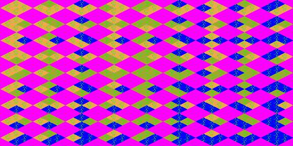
If anyone decides to make thier own terrains, This Tool that I made up, is quite helpful. Since the terrain files xdgc, xdgp, xdpc, xggc, xpgc, xtgc, xdgp and the Water Times wCSO, wSSS and wOOO. follow the same pattern, but are hard to determine if you look at them one at a time...
Note: xdgc is what I used: desert, grassland, coast to make the file.
Heres a pic of what the 'terrain' file looks like, and then I'll post the file afterwards
EDIT: See new post
 Attachment: terraforma.jpg Attachment: terraforma.jpg
This has been downloaded 91 time(s).
Last edited by Bane Star on 29-06-2003 at 12:30
|
|
| |
|
|
|
Bane Star
|
|
Adelaide, Australia
Sep 2000
time: 14:59
|
|
and for anyone who wants it... the file
 Attachment: terraforma.rar Attachment: terraforma.rar
This has been downloaded 8 time(s).
Last edited by Bane Star on 29-06-2003 at 12:10
|
|
| |
|
|
|
BlueWlvrn
|
|
Now, do you have the image number that goes with each in the BIC/X file?
With that, and this very easy to read graphic, I'll be a lot further along with my map test.
Thanks
BlueWlvrn
|
|
| |
|
| |
|
|
|
BlueWlvrn
|
|
Actually I figured it out.
In the bic/bix file, each tile of the map is defined. That definition contains the basic tile data as well as what graphic to use.
It turns out, the graphics grid, and the map grid, are offset.
code:
 /\
/  \
\/\/
/\/\
\  /
 \/
The diamonds represent the grid squares. But the graphics grid, is offset by half to the north.
So if the bottom diamond is the normal game grid, the top diamond is the actuall graphics grid (those tiles in the pcx file). You can see that actually only the bottom corner of the pcx image needs to match the current tile being defined in the bic. The other three corners must conform to its 3 northerly neighbors.
So, using the following formula, you can get the image number that a tile in the bic file refers to.
Assuming the first terrain type is enumarated as 0, then 1 and 2.
B = terrain type on bottom of graphic, current tile in bic
L = terrain type on left, up one row to the left in bic
R = terrain type on right, up one row to the right in bic
T = terrain type on top, straight up two rows in bic
Row = 3*B+R
Col = 3*L+T
row and column are the row and column in the pcx file.
ImageNumber = Row*9+Col
Image number is the byte value used in the TILE section of the bic/bix file.
Well now that should make it clear as mud.
|
|
| |
|
|
|
Yoda Power
|
|
here is the old file
(dont download it as it is obselute)
Attachment: terraforma.rar
This has been downloaded 1 time(s).
|
|
| |
|
|
|
BlueWlvrn
|
|
Warp:
I'm creating a new random map engine with a couple ideas I've been tossing about.
And as a side effect, I hope to be able to mirror it in a way to make "equal" start location maps for multiplayer.
But for the most part, I'm just tinkering.
|
|
| |
|
|
|
Bane Star
|
|
Adelaide, Australia
Sep 2000
time: 14:59
|
|
When you look at the graphics in the graphics pcx file, its somewhat hard to determine, This makes it hard to see which terrain is which when editing, but I forgot to explain how they work,
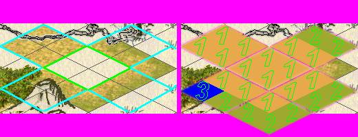
Good idea blue wyrm, a picture is worth a thousand words so Heres one of my old screen shots from when I was mid-map-editing.
In the centre is 4 Plains, The left Image shows the map grid and my colourd grid to show where the terrain images sit, then on the right is the terrain images via the file I've added above. At the time of this screen shot I had only edited Grasslands, repersented by the green number 2, The forest is no.3 and the plains no.1 ... hopefully you can see how the graphics are split up and why I needed to make the terrain file above to determine which terrain is which.
When you start looking at the coastal tiles they are pretty hard to see which are which since there is no uniformity, and many of them go inland too much (seen those forests off mid ocean or troops standing one foot on land and one in the water..)
Hope this helps
Attachment: terrainshow.jpg
This has been downloaded 40 time(s).
|
|
| |
|
|
|
BlueWlvrn
|
|
Bane,
Once I figured out the offset of the pcx files from the game grid, your numbered pcx file was perfect.
Thanks for making that up, it also made it easier for me to come up with the simple formula for the image number used in the bic/bix files.
-BlueWlvrn
|
|
| |
All times are GMT. The time now is 05:29.
Apolyton Time is 00:29. |
top of page
|
|
|
Forum Rules:
You may not post new threads
You may not post replies
You may not post attachments
You may not edit your posts
|
HTML code is ON
vB code is ON
Smilies are ON
[IMG] code is ON
|
|
|
|
|
|





 29-06-2003 11:12





 thanks man,.,.

 |
|