 |
| |
|
![Impaler[WrG] is offline](/forums/images/off.gif)
|
Impaler[WrG]
|
 |
Cheif Manufacturing Officer of Morgan Industires
May 2002
time: 22:32
|
|
I have started this thread to reveal a few things I have learned about the global Geography of Planet. I sugjest we keep this thread toped and add additional information as it becomes avalible, eventualy making a kind of Atlas.
First off I have constructed a cruide hand drawn map (so unfortunatly I cant post a picture). By clicking around randomly and using the Base non-recentering trick I have and will continue to roughly locate the heartlands of hidden factions and roughly outline the land masses they rest upon.
My first discover is that their is a faction located on the Large high altitude island Centered on (26,58). As you can see from the grid lines this is a compact high altitude island, the factin located their will have abundant solar energy and rocky squares but might have nut problems. I belive this is the Drone Faction because its a short trip away from the drone scout thats exploring our territory and the Drones are conducting a bit of trade with us, sugjesting they have resonable energy.
I managed to find 8 bases total on that land mass, they are. (26,58) (19,57) (28,66) (22,64) (30,56) (30,70) (40,66) (33,53). Most seem to be located along the edge and are likly Coastal Bases. Directly south of this Island their is a large aparently empty Sea with indications of a small island near the bottom of the map.
This would also mean that PEACE is just off the Eastern Shore of this Faction. If this is true and these are infact the Drones then they might be in an excelent position to start a 2 front war with PEACE. We should inquire with the Drones if this is correct and when we start the war we should send them a message saying that we encourage them to take PEACE bases and will be willing to give them inteligence in order to do so with, thus cementing an Aliance with them.
My next observation is that the Belivers must be located on the lumpy land mass East of us. Their Copter has a range of 8 so its the only place it could have come from. And what do you know their is infact a base as (82,82) adsactly 8 spaces from the Copter. Miriam is not realy in a position to do anything to our enemies as she likly lacks boats. I think that when we are done with PEACE we should look at attacking the Belivers. Their going to vendeta us soon after we go Democracy anyways so its no big loss. We can most likly clean them up easily with out tec advantage and add substantial territory to our Empire.
We now also know that University is North of us. I suspect they are on a compact group of islands conected by necks and stratis much like our own is (this seems to be a theam the map maker used). Using our Navel Power against the university seems like a definate option along with using amphibous units and transports to "walk" onto the chunk of land that contains the Ruins (a nice place to get upgrades by the way).
PEACE as we already know is spread across an Archapeligo of small sand bar islands that extend Westward from our territory. North of this Archipelago their is an empty Sea that likly marks the Edge of Pirate territory. North of this Sea their seems to be a Chain of Islands running East to West, it might actualy be one continuous land mass or as I suspect is a chain of "necks" and "straits". I do not shure if this area is inhabited or not. Aditional cliking in he Dark is required.
A large unmistakable land Mass rests near the North Pole streatches from around 80 longitude across the "Prime Meridian" to the 30 area. This large land mass contains Sunny Messa and Pholus Ridge as is obvious from the shape. Most likly this all belonges to one faction. I belive its the Hive, but it might be the Angels. In either Case the other faction is likly on the much lower elevation terrain that is seperated by a large sea that runs in an arc along the Eastern end of this land mass and above the suspected Drone Island.
Possible Uninhabited Island are located North East of Pi Squared in the area of (63,42). Controling these could prove strategic for attacking PEACE or the University and for exploring the Island Chain that lies to the west and far north. In any event we want to plant the Cycon flag their before anyone else moves in.
I encourage anyone with time to kill to do a bunch of cliking in the dark, particularly in the Northern reaches of the map. Identifying base clusters and the extent of other factions territories will be invaluable in future planning. Post any data you colectt or insights on the map here.
EDIT: SORRY! I edited this post instead of quoting it! I have restored it, but didn't realise you could edit others' posts in sub-fora apart from the Civ3 ISDG one! 
Edit by Maniac: I'll make a list of all mentioned base coordinates in this thread in this first post. Handy for quick reference.
Angels?: (26,58) (19,57) (28,66) (22,64) (30,56) (30,70) (40,66) (33,53)
Believers: (82,82) (81.77)
PUT:
(78, 50) Base in middle of Ruins
(78,44) Monitoring Station
(80,38)
(78,34)
(76,30)
(73,31)
(84,30)
(82,34)
(87,33)
(76,38)
(80,30)
Suspected Drones Bases:
(3,3) (92,4) (85,7) (91,9) (80,10) (74,10) (87,13) (94,16) (92,22)
Border Bases (could belong to either, plobly a split):
(4,14) (6,18) (2,20)
Suspected Hive Bases:
(25,15) (22,16) (18,16) (14,18) (29,19) (21,11) (22,20) (17,21) (29,23) (26,26) (22,26) (18,26) (26,30) (10,18)
PEACE:
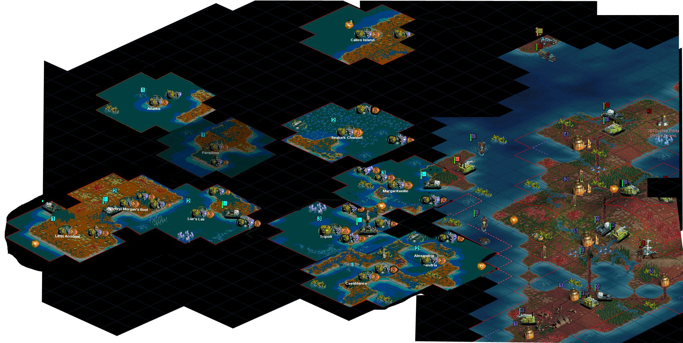
Casablanca (55,75)
Sea Lurk (54,56)
Alexandria (59,73)
Margaritaville (57,63)
Tripoli (53,69)
Calaco Island (55,43)
Pampalon (46,58)
Liar Liar (45,67)
Atlantis (42,52)
Henry Morgans Boot (40,66)
Little Accident (36,70)
Please also see the PEACE map here.
Last edited by Maniac on 05-12-2003 at 05:08
|
|
| |
|
| |
|
| |
|
|
|
Impaler[WrG]
|
|
Cheif Manufacturing Officer of Morgan Industires
May 2002
time: 22:32
|
|
University Surrvy is now complete.
The university is higly compact, thier core bases are all 2-3 squares apart most likly for rapid reinforcment of ground units and defensive probe teams.
I estimate that the Whole University Island is less then the size of our own Developed land area, yet the University seems to have not even finished filling in their small island as their bases are being places so close together. Their Bases are clustered just North of Monitoring Station in a triangular shape with Monitoring Station as downward point of the Triangle. Their is amble room for expantion to the East of this group of bases and they are aparently using the "B" land mark to denote their future base sites, their are probly a half dozen such B's covering the Easter half of their land. In total they have 11 bases like we do.
(78, 50) Base in middle of Ruins
(78,44) Monitoring Stations
(80,38)
(78,34)
(76,30)
(73,31)
(84,30)
(82,34)
(87,33)
(76,38)
(80,30)
I think this all reflects a Paranoid Defensive Build up strategy, that combined with the fact the University lacks even basic offensive tecs like Aplied Physis means we have nothing to fear from them for the time being. I also plan to Ask Googlie if University is alowed to hog land marks like this as I noticed that all 64 alowable landmarks have been used and we are only using 1 non-natural Land Mark!
|
|
| |
|
|
|
Impaler[WrG]
|
|
Cheif Manufacturing Officer of Morgan Industires
May 2002
time: 22:32
|
|
I have completed the Norther Survey now, it was quite a bit easier because of theirs only one continent to search. I am fairly sertain that the Hive and Drones are SHAREING that northern continent, their Pact is to prevent either side from launching a pre-emptive attack upon the other as you would usaly do when you share a continent like this.
Bases their clearly fell into one of 2 base building paterns and Dense 2-3 space and a wide 5 space between bases. I belive the Drones are the Northern and Western low density group and the Hive is the South Eastern high density group (because this group has slightly more bases). Their is a bit of a "no mans land inbetween.
Suspected Drones Bases
(3,3) (92,4) (85,7) (91,9) (80,10) (74,10) (87,13) (94,16) (92,22)
Border Bases (could belong to either, plobly a split)
(4,14) (6,18) (2,20)
Supsected Hive Bases
(25,15) (22,16) (18,16) (14,18) (29,19) (21,11) (22,20) (17,21) (29,23) (26,26) (22,26) (18,26) (26,30) (10,18)
Their is considerable undeveloped land north and South of the dividing line that seperates the Groups, the dividing line seems to run between 2-6 degrees Longitude.
Speculations. If the Drones are ware I think they are then it would seem ilgical for them to have sailed a boat down to find us without having made contact with the University which they haven't. I suspect their Scout fell through a dimentional rift wial Pod Popping. The Drones most likly have little or no navy. With all factions accounted for its now clear that the map contains a giant empty zone North of Peace which takes up half the Northern Hemisphere. I belive this area contians at most scattered Islands like PEACE occupies. It seems our Position on the map is Quite advantagous we are in a position to strike at 3 outer major powers, PEACE, Uni and Belivers which are to our West, North and East respectivly. Hive and Drones and Angels are comparitivly more isolated.
|
|
| |
|
| |
|
|
|
Impaler[WrG]
|
|
Cheif Manufacturing Officer of Morgan Industires
May 2002
time: 22:32
|
|
Using pact data and earlier Base Cordinates I have now completed a list of all the Hives base.
Voltograd (22,20)
Central Planning (17,21)
HongHu KongHu (18,16)
RokossovkyGrad (29,23)
GooglieGrad (22,26)
OctanianBurg (21,11)
Utopia Base (10,18)
Michanopolis (18,26)
New Moscow (26,30)
VandenBurg (22,16)
Static univeristy (6,18)
Vevtopia (14,18)
Kommuniza City (26,26)
Jamski's Prison Cell (24,6)
Great Clustering (14,22)
The Hive (29,19)
Yang Base (22,30)
Jamski's Coup (25,17)
If Drouge or WIA can assemble a map of Hive territory using this info and Post it here that would be greatly apresiated, The new university information reveals a good chunk of the un-used territory to the west of the Hives Core area which is centered on Voltograd. New Moscow the source of most of their Navy and the Probe Foils which threaten the University is very far away and must pass through waters the University has explored meaning its likly to be detected.
Also I was able to figure out the tecnique Kody used to find all the bases on the Planet, He takes a unit selects and holds then drags off a "move to" line which will display the fastest route to move to any point and the # of moves needed. By dragging this line into unexplored territory you can see unexplored base, they apear as "move to Blank" so one is able to learn the bases name in additon to its location. It might also be possible to identify the outlines of land masses with this tecnique and we can use it to better plan the movment of our navy as it seems to detect fungus and instruct units to go around it.
|
|
| |
|
|
|
Maniac
|
 |
Gent, Belgium
Jul 1999
time: 06:32
|
|
quote:
Originally posted by Impaler[WrG]
Voltograd (22,20)
Central Planning (17,21)
HongHu KongHu (18,16)
RokossovkyGrad (29,23)
GooglieGrad (22,26)
OctanianBurg (21,11)
Utopia Base (10,18)
Michanopolis (18,26)
New Moscow (26,30)
VandenBurg (22,16)
Static univeristy (6,18)
Vevtopia (14,18)
Kommuniza City (26,26)
Jamski's Prison Cell (24,6)
Great Clustering (14,22)
The Hive (29,19)
Yang Base (22,30)
Jamski's Coup (25,17) |
Some base name changes:
Central Planning->Kody's Legacy
Utopia Base->Meadopolis
Jamski's Prison Cell->Jamski's Redemption
Great Clustering->Enigma's Vengeance
The Hive->Dacolopolis
Yang base->Frankyburg
Jamski Coup->Seat of Unity
New base: Zeropolis (10.26)
|
|
| |
|
| |
All times are GMT. The time now is 05:32.
Apolyton Time is 00:32. |
top of page
|
| archivepost |
|
Forum Rules:
You may not post new threads
You may not post replies
You may not post attachments
You may not edit your posts
|
HTML code is ON
vB code is ON
Smilies are ON
[IMG] code is ON
|
|
|
|
|
|





 29-11-2003 22:17
![Visit Impaler[WrG]'s homepage!](/forums/images/homepage.gif)



 This will prove very handy.
 ), they mentioned IIRC that they were close to the Angels, or at least that they could quickly infiltrate them. In later DocFlex negotiations when I asked them why they wanted us to research and give them a military tech, they said they feared AI factions. This leads me to believe that the Angels are their neighbours, not the drones. Especially since PEACE contacted the Angels way sooner than the Drones.









 )
)
 |
|