 |
| |
|

|
yellowdaddy
|
 |
Saoir-Ebhor, Sasainn a tuath, Rialtas Aontach
Apr 2003
time: 05:35
|
|
This topic deserves a new thread, especially as Gattsuden and I will be hopefully producing some new urban overlays.
Jack said:
quote:
areas of settlement/urbanisation as collections of little buildings which can form a range of city shapes, and (with each little house representing say 10,000 people, and perhaps little factories/smithies and commercial edifices to represent the varying sizes of the industrial and commercial sectors - like a scaled-down and simplified Sim City) a graphical representaion which refects the size/density/distribution of settlement?
or can't you be arsed with that?
do you just want simple one-square standard size cities like in Civ? |
Mark E said:
quote:
I think your cocept is intriguing. However, I found the examples currently on your web page to be hard to discern from the terrain. Since cities need to be easily-resolved when placed on a wide range of terrain tiles, that isn't a trivial problem. Also, the coding infrastructure to handle something like that does not yet exist. But we did plan to do similar things for tile graphics for forests, where deforestation would show nearly-continuous thinning of trees. So I expect that the code to handle such things will be there at some point. However it's not a priority at the moment. That is why I expect Gary is asking for the traditional whole-tile cities for the moment. We will be using them for a significant amount of time I expect. |
Jack said:
quote:
The idea of having Flora, Fauna and Urban overlays growing, spreading, changing organically is truly an original and exciting game feature if implemented.
There'll be implications for the military model as well as the economic model I imagin.
Gone are the days where you move a 1 square-filling mobile unit onto a 1 square-filling static unit (city) with two dimensional results, Bring on the polygon map and organic settlements!
{How would you attack a swathe of mountain villages or }
{scattered farmsteads! you'd need to really develop the Task }
{Force idea, so you could add mongol horde-style raids perhaps.}
{different strategies too for coastal and riparian linear }
{settlements. }
{I suppose you'd need to assign admin centres or city }
{centres, as you click and draw your internal administration }
{borders, so that there is some defined place for an enemy to }
{capture, or which could potentially revolt and set up as another}
{citystate or part of another nationstate. }
{ }
{I think this would be a fascinating break from Civ where you }
{have strategic wars instead of just one-on-one unit battles. }
{ }
{When campaigning against sparse settlements and straggly }
{areas of settlement, you could capture each building one by }
{one, and thus have a defined area of control on the map, and }
{even end up in a stalemate where a large city is divided }
{between enemies. }
{ }
{As for the issue of visibility of these tiny buildings, well , one }
{solution is to have an urban background overlay - it needn't be }
{solid either - a grey/brown tint. And for the houses use more }
{contrast and shadows - i'll amend them. } |
Laurent said:
quote:
About evolution of images: Note that I've already coded a class that lets a unit use different images as techs evolve. This could be reused for terrain, but tying the evolution of graphics to a tech would not be what we want for forest, though it might for cities (city styles). |
Jack said:
quote:
I meant evolution in terms of City size and shape ( the area of land it covers and the shape of it - whether it curls round a beach, along a river, or radiates from a point absorbing other cities adjacent to it)... you start off with a celtic village of London or Paris, and over time more an more little buildings are added and after 2000 years you have a sprawling monster of a city... (catchez-vous mon drift?) |
Laurent said:
quote:
I got it. This has more or less been implemented in a CtP2 mod by the way (sprawling cities). I was just mentionning what's already coded and possible. |
Jack said:
quote:
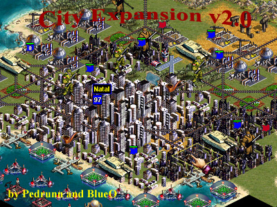
you mean this? http://apolyton.net/forums/showthre...threadid=105525
Well this is very similar to what I mean; you could have urban squares along a river or coast, or two or more cities merging, but it's still on the whole square scale.
the limitations with that is that it's still one city one square.
What I'm trying to describe has a different and more realistic scale, than the above Ctp2 mod.
I'm talking about a different approach where you display all habitiation on all tiles...
...including nomadic camps which could pop up one turn and then change to a caravan unit the next, and...
...a range of (maybe 4) population densities:
"scattered villages" (including single village or outpost)
"towns and villages" (a town with some nearby villages)
"city and villages (a city with villages and/or towns around it)
up to big "metropolises" (as big and sprawly as you like)
any merging of "cities" and "metropolises" called "conurbation."
The object is to create a map which bears more resemblance to what you might see in an Atlas of the world.
|
Last edited by yellowdaddy on 04-04-2004 at 17:21
|
|
| |
|
| |
|
| |
|
|
|
yellowdaddy
|
|
Saoir-Ebhor, Sasainn a tuath, Rialtas Aontach
Apr 2003
time: 05:35
|
|
you're right, I have wandered, but the initial subject reached a natural conclusion, unless Laurant has something to add.
I think this subject below is worth bringing up, i'm not sure what's planned, but I don't think the way the city and province management wrks in D7 is particularly satisfying.
.............................................................................
...so you're not having a "city management screen" as in Civ?
In the game you have the economic sector figures in one box... then you have the units present in a city in the top left, then there's nothing for the governorship of a city - i'm recalling ctp where you had your managers and set them tasks like "expand" or develop "farming".
I find that it's not always clear whether you are doing something to the province or city.
I think it'd be nice to make it a little clearer, and perhaps bring all the data together in a "view province" screen and "view city" screen.
simple things like making the selected object flash on and off, be it a unit, city or province - i think that you should be able to display the provincial borders on the map.
a screen pops up (or exists in the top right in the prototype interface on my site) and you have a zoom-in of the province or city, and some tabs to choose which aspect you want to view or adjust: economic, social, military, political (the character) - not unlike those screenshots from Imperium i posted above on this thread.
|
|
| |
|
|
|
Max Sinister
|
|
Just asking for curiosity:
If you program the game with irregular polygons instead of squares/hexes/rects, will you implement them in a way that every polygon will have a list of other polygons (its neighbors)?
|
|
| |
|
|
|
Mark_Everson
|
 |
Canton, MI
Jan 1970
time: 00:35
|
|
quote:
Originally posted by yellowdaddy
so you're not having a "city management screen" as in Civ? |
Oh, we probably will. But I think getting the "model" interfaces down first is much more important. Remember, in Civ, cities are the main functional entity in the game. Cities in Clash are much less central to the game. I think many players will open screens for cities, other than perhaps the capital, very rarely if ever. That is why I'm not so interested in the topic at the moment.
quote:
I find that it's not always clear whether you are doing something to the province or city. |
This is perhaps a legitimate criticism. The next version of the gui should make sure to make that clear, maybe graphically. Although, in our defense, it usually does say in words on the top if it's a square or province. . .
quote:
simple things like making the selected object flash on and off, be it a unit, city or province |
Sorry, but I absolutely detest that. It gives me headaches, literally.
quote:
- i think that you should be able to display the provincial borders on the map. |
That is Already what is done. See the Carthge scenario, Italy is a province and Gaul is, and you can see it on the map!
quote:
a screen pops up (or exists in the top right in the prototype interface on my site) and you have a zoom-in of the province or city |
I've got no big problem with that, it'd probably be useful. But it isn't a high priority from my point of view. YMMV.
|
|
| |
|
|
|
PresidentMarcos
|
|
My question is: When will the graphics for settled areas improve? Naturally, I want something a little more fancy than a colored border. Little buildings and such would be just enough.
|
|
| |
|
|
|
yellowdaddy
|
|
Saoir-Ebhor, Sasainn a tuath, Rialtas Aontach
Apr 2003
time: 05:35
|
|
quote:
PresidentMarcos My question is: When will the graphics for settled areas improve? Naturally, I want something a little more fancy than a colored border. Little buildings and such would be just enough. |
I'm working on this at the moment. I won't post them on my site until I've finished them. I don't think there's a mad rush to finish them, as D8 is not going to be out before summer. I won't have much to show until June anyway, as I'm a house-husband/student/pt office dolly, and we're moving to another town.
There will be 6 city sizes (4 being actual cities, the other 2 being "nomadic camp" and tiny "outpost"), and at least 6 styles.
There'll also be ruined versions of each, and walls overlay.
You're most welcome to help if you can 
__________________________________________________
__quote:
Although, in our defense, it usually does say in words on the top if it's a square or province. . . |
true, but squinty goldfish-brain types like me can still manage to miss it! 
quote:
Sorry, but I absolutely detest that. It gives me headaches, literally. |
how about a glowing aura then?
maybe it's just me, but i like to see a noticable visual change on screen to reassure me that the computer is not ignoring me!
(i'm one of those "click save three times to be sure" types)
quote:
That is Already what is done. See the Carthge scenario, Italy is a province and Gaul is, and you can see it on the map! |
yeah, but could we make the international borders bolder than the provincial ones? or perhaps make the internal one dashed lines?
_________________________________________________
quote:
Just asking for curiosity: |
ooh, don't get 'im started! have you read through the "map graphics 2" and "polygons and microterrain" threads?
|
|
| |
All times are GMT. The time now is 05:35.
Apolyton Time is 00:35. |
top of page
|
|
|
Forum Rules:
You may not post new threads
You may not post replies
You may not post attachments
You may not edit your posts
|
HTML code is ON
vB code is ON
Smilies are ON
[IMG] code is ON
|
|
|
|
|
|





 04-04-2004 15:44


 |
|
 |
|