|
| |
|
| |
|

|
Illuminatus

|
 |
Salvaging Unity Fusion Core
Jul 2003
time: 06:37
|
|
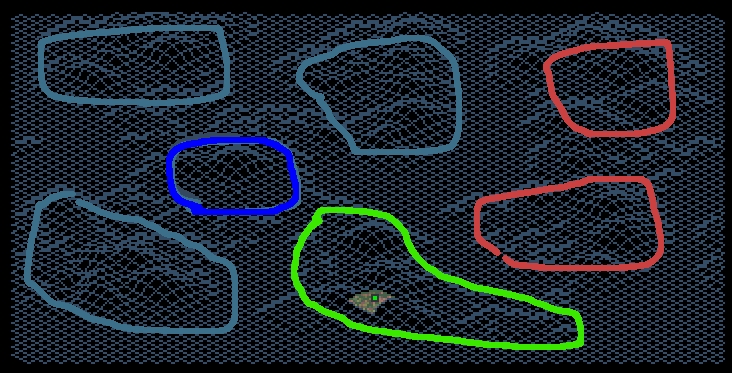
And here I present you, the world! Using extreme zoom out, hills appear cleary on map. If we assume that each concentration of hills is a continet, we get seven continents. Notice supersized X-shaped continent.
Buster (game creator) said that each faction will run into Hive. Also, notice that Gaians are on one of four ends of x shaped supercontinent. If we also take in consideration that each faction has a balanced starting position, which is approximately distanced equally from other factions, we can assume that on each of four ends of X-continent is one of four human controlled factions. A very reasonable assumption. Also, I am completely sure that if this assumption is correct, then Hive must be in the center of the X-continent. This also explains claim that each faction will run into Hive first.
There seem to be two continents, or a landmass with huge two land masses in the northeast from us. If we assume that for each of seven continents goes one of seven factions, and we already know that X-continent is occupied by five factions, we can safely deduct that Lal and Zak are on these two landmasses.
Legend:
Green - rough shape of our continent
Mudblue- continents of other three factions
Blue - center of X-shaped continent assumed containing Hive
Red - other factions on a pair of two continents/continent with two large landmasses
 Attachment: chironeek.jpeg Attachment: chironeek.jpeg
This has been downloaded 89 time(s).
|
|
| |
|
|
|
Illuminatus
|
|
Salvaging Unity Fusion Core
Jul 2003
time: 06:37
|
|
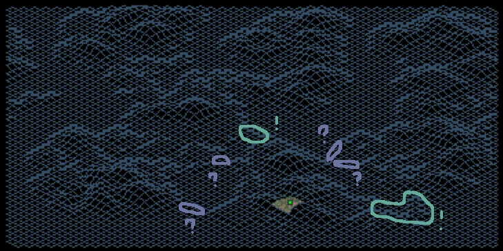
Further analysis shows several more facts: there are two almost completly sure landconnections to other land regions - one that connects us with center of X-supercontinent and one to the southeast that connects us probably with landmass of other two AIs. There is also a wide range of possible landbridges represented on map with indigo and questionmarks. We can guess that Garland crater is in the upper right ends of X-continent, meaning that there is probably at least one landmark per factions. There is an elevation to the north of us that could be Mt Planet, but I cannot say this is probably true, infact, it is probably wrong. I guess that landmark for our faction could be Ruins or Manifold Nexus, and is probably to the east, in barren wastelands (as smacksim clevery proposed).
Only true exploration will solve this mistery. However, facts laid here are to be noted, and taken carefully in future, when planning colonisation and exploration missions.
-acting GAIA director, Obstructor
Attachment: landconnections.jpeg
This has been downloaded 84 time(s).
Last edited by Illuminatus on 30-06-2004 at 01:08
|
|
| |
|
|
|
smacksim
|
 |
Deputy Chairman of the Council of Lords of Gaia
Feb 2004
time: 00:37
|
|
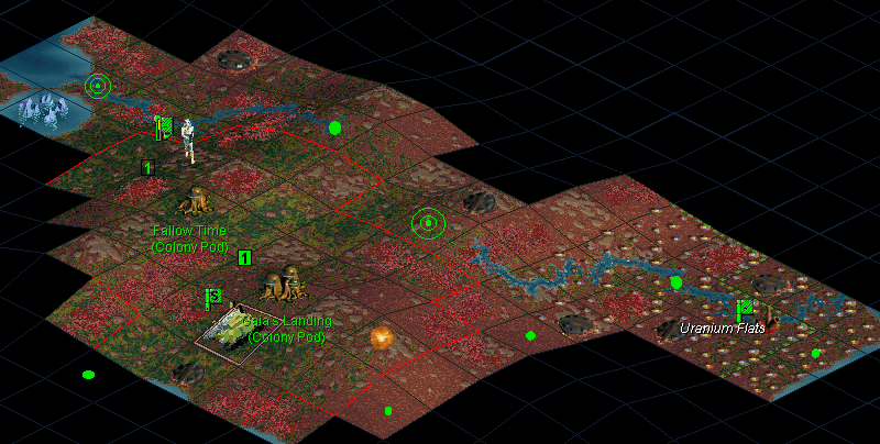
That's looking an awful lot like the dunes to our East! Ack. I suppose it could be the Uranium Flats, but I really doubt it. I concur with seeing the Unity wreckage to the NE. The scenario maker did make several Mt. Planet-like areas, so no luck figuring that out.
On the other hand, we have a good long stretch of western-slope (wet) land almost straight to the north. As this is also the direction of all our contacts, surely, I propose colonizing in that direction until we know more about our landscape.
Also, if the Hive is in the middle, we'll want to figure out a way to get around them for contact and probe actions. Probe-foils would be nice, IF there's any ocean to speak of. Also, what are our long term SE plans? If we plan on running green, our navy could get started sooner with a prompt finding of the coastline.
-Smack
|
|
| |
|
|
|
Illuminatus
|
|
Salvaging Unity Fusion Core
Jul 2003
time: 06:37
|
|
I am analysing map again, and I have found what it seems to be very likely, Sunny Mesa at coordiantes 5,25. No other grid line looks similar to Sunny Mesa, and this ones has very artificial plateu outline, so we can count two landmarks located. Also, I tried to determine if thet thing north is Mt Planet - I cannot tell - you see each 3500 elevated mountain produces the same grid outline  so we cannot tell in advance. Well we shall find out in 10-15 years anyway. so we cannot tell in advance. Well we shall find out in 10-15 years anyway.
EDIT: Also, by testing in map simulator I confirmed it all, and additionally, I now think that UNS wreckage is located near in 82,30 84,20 86,34 0,32 (edge coordinates) with center in 85,31.
There is also Nessus Canyon with center in 21,71.
Last edited by Illuminatus on 02-07-2004 at 19:54
|
|
| |
All times are GMT. The time now is 05:37.
Apolyton Time is 00:37. |
top of page
|
|
|
Forum Rules:
You may not post new threads
You may not post replies
You may not post attachments
You may not edit your posts
|
HTML code is ON
vB code is ON
Smilies are ON
[IMG] code is ON
|
|
|
|
|
|





 30-06-2004 00:35




 We shall soon find out if they discovered one of human team bases, or base of an AI.
 Also, try not to disapprove this idea, and mention project Pegasus unrelated, but do not explain what it is

 Attachment:
  |
|
 |
|