|

|
Quezacotl06
|
|
I think all pre-industrial age ships should all be able to travel through rivers.
It gives civs better expansion abilities, especialy coming to transport of units in galleons and stuff
|
|
| |
|
|
|
Naokaukodem
|
|
What are straits???... anyway we need another civ, not civ-v4. We need a distinctive management of population to create civilization divisions, unions, another type of war... etc.
|
|
| |
|
|
|
Straybow
|
 |
SG(2)… gone but not forgotten
Jan 1970
time: 23:33
|
|
G-pa Troll, there is a canal through the Great Dismal connecting the Chesapeake to Albemarle Sound, and a canal cutting across the peninsula from the Neuse southward.
* Straybow decides to Google some details the grey matter has misplaced
From Atlantic Intracoastal Waterway
quote:
The Intracoastal Waterway is a navigable toll-free shipping route, extending for about 3,000 miles (4,800 km) along the Atlantic Ocean and Gulf of Mexico coasts in the southern and eastern United States. It utilizes sounds, bays, lagoons, rivers, and canals and is usable in many portions by deep-draft vessels. The route is federally maintained and is connected to inland waterways in many places. It was originally planned to form a continuous channel from New York City to Brownsville, Texas, but the necessary canal link through northern Florida was never completed; hence, it is now in two separate sections--the Atlantic and the Gulf.
The Atlantic Intracoastal Waterway serves ports from Boston to Key West, Fla. The route is linked by several essential man-made canals, including the Cape Cod, Chesapeake and Delaware, and Chesapeake-Albemarle. The lowest controlling depth is 6.1 feet (1.9 m) in the Dismal Swamp Canal of Virginia and North Carolina. During World War II, the route became important as a means of avoiding the submarine menace along the coast. Commercial traffic (oceangoing vessels and barges) serves the heavily concentrated industrial areas north of Norfolk, Virginia; whereas, to the south, the waterway accommodates mainly pleasure craft traveling to the Florida resort areas. |
When you read about the Grand Canal in China there are stretches that were never very serviceable due to annual flooding and low water periods, the Huang He's turbulence, etc.
|
|
| |
|
|
|
Grandpa Troll

|
 |
I owe..I owe..it's off to work I go
Jul 2000
time: 00:33
|
|
quote:
Originally posted by Straybow
G-pa Troll, there is a canal through the Great Dismal connecting the Chesapeake to Albemarle Sound, and a canal cutting across the peninsula from the Neuse southward.
* Straybow decides to Google some details the grey matter has misplaced
From Atlantic Intracoastal Waterway
quote:
The Intracoastal Waterway is a navigable toll-free shipping route, extending for about 3,000 miles (4,800 km) along the Atlantic Ocean and Gulf of Mexico coasts in the southern and eastern United States. It utilizes sounds, bays, lagoons, rivers, and canals and is usable in many portions by deep-draft vessels. The route is federally maintained and is connected to inland waterways in many places. It was originally planned to form a continuous channel from New York City to Brownsville, Texas, but the necessary canal link through northern Florida was never completed; hence, it is now in two separate sections--the Atlantic and the Gulf.
The Atlantic Intracoastal Waterway serves ports from Boston to Key West, Fla. The route is linked by several essential man-made canals, including the Cape Cod, Chesapeake and Delaware, and Chesapeake-Albemarle. The lowest controlling depth is 6.1 feet (1.9 m) in the Dismal Swamp Canal of Virginia and North Carolina. During World War II, the route became important as a means of avoiding the submarine menace along the coast. Commercial traffic (oceangoing vessels and barges) serves the heavily concentrated industrial areas north of Norfolk, Virginia; whereas, to the south, the waterway accommodates mainly pleasure craft traveling to the Florida resort areas. |
When you read about the Grand Canal in China there are stretches that were never very serviceable due to annual flooding and low water periods, the Huang He's turbulence, etc. |
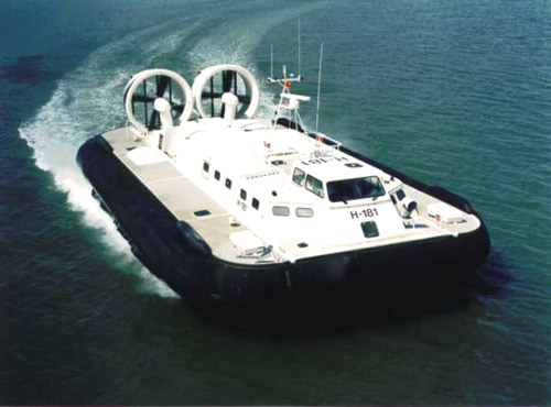
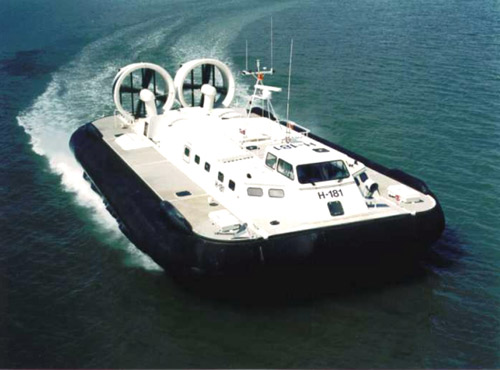
Well, I live here and I am here to tell ya..I find it hard to believe that you can take a ship through woods and across flatlands...maybe you were speaking about an LCAT a military hovercraft
and for the record we do have an intercoastal waterway..but it is more like a mish-mash of small slips where many boats go to get out of the main gulfstream and graveyard of the Atlantic that may require your soul 
Ok..I meant as a matter of fact not so much "Its there..ya just cant use due to swamp,flooding,drying,Elvis was here signs, The Great Pubaa is using,ect.
It just doesnt exist to be in use for any watercraft like Destroyers and Battleships or ships of the line
This was what I was referring to
 Attachment: hovercraft.jpg Attachment: hovercraft.jpg
This has been downloaded 64 time(s).
|
|
| |
|
| |
|
|
|
frekk
|
|
quote:
Well, I live here and I am here to tell ya..I find it hard to believe that you can take a ship through woods and across flatlands |
The Rideau Canal (between Ottawa and Kingston) passes through hilly, rocky, forested terrain of the Canadian Shield. It's the oldest canal still in use in North America, one of the largest in the world, built on totally uneven land through a system of locks. Some credit it as being the biggest engineering feat of the 19th century. Incidentally, it is also completely inland - it connects the Ottawa River to Lake Ontario.
It can't handle an oil tanker, thats true, but it was more than sufficient for the largest ships of the 19th century.
|
|
| |
|
| |
|
|
|
MiketheYounger
|
|
With a few very minor exceptions, strits IRL on Earth are wider than the Rhein River. The Rhein has never been forced without naval assistance. Straits are great, but you still need a boat to get across
On June 26, 1959 HRH Queen Elizabeth II and President DD Eisenhower opened the St Lawrence Seaway, connecting Lakehead, Wisconsin with the Atlantic Ocean. The locks are 766' x 80' x 30'. 40,000 people operate the Seaway, with a 1997 payroll of $2 billion. Construction took 4 years. How's that for a hearty heaping helping of economic whoopass? Canals can be done in CIV, and, IMH, should be done.
|
|
| |
|
|
|
frekk
|
|
I have wanted canals in the game since Civ1. It would be easy to turn them off for people who don't like them, but it's a feature alot of us would appreciate as it would add considerably to the game.
Also it would allow one to replicate the mass transport system that came before rails, which was (at least in late 18th and early 19th century industrialized Europe) a vast network of canals plied by steam vessels - still in use to some extent. And then there is the obvious, from the St. Lawrence locks to the Kiel Canal to the Suez and Panama. Yes ... you can build a city to allow passage through one tile but often on a world map, you can't build the Suez because it ends up being 2 tiles, you can't build the St. Lawrence seaway because it is a river and ships can't use rivers, you can't build the Kiel because it is often about 3 tiles, many more on just a Europe map. And canals aren't cities. Also these feats were not possible before the industrial age, how can this be replicated in the game without canals?
|
|
| |
|
|
|
dmd175
|
|
Culturally linked starting location.
Oct 2003
time: 00:33
|
|
quote:
Originally posted by star mouse
* They would be built like any other terrain improvement but take a LONG time to construct. (How long did the Panama canal take to build and with how many workers?) There are also restrictions:
* Can only be placed next to the coast.
* Can only be placed on a flat tile.
* Can only be placed such that the canal is one or two tiles in length and the canal is on an isthmus.
* Costs money to build.
* The canal replaces mines and irrigation.
|
Canals are an idea that I too have had since civ2. I think it can be easily implemented into Civ4 as a terrain improvement/worker function, and I am in general agreement with the above.
However, I don't think it necessarily has to be next to the coast. The Erie canal for example ran through forest and arguably hilly terrain (looking for a good topographic map of NY state. Try here for now http://docs.unh.edu/nhtopos/NewYorkList.htm).
The length I agree should have some cap. However, in Civ3 one tile = 100 square miles --> length and width of tile = 10 miles. The Panama Canal is about 50 miles long and Erie is 360+. Thus I think 1-2 tiles is too restrictive for a canal, while 36 might be a bit to generous. I think something like 5-6 might be acceptable, though we can make costs rise exponentially in terms of money and worker time for longer canals.
As far as what the canal does to the tile production capacity, I vote for some sort of hybrid system. So the canal obviously disrupts whatever baseline capacity there is, ie if there is a tile producing 4/2/2 f/s/g, then I think that should decline by 1/2. The canal would be represented basically by a modified river graphic taking up 1/2 of the tile. Though food and shield output decrease in the canal tiles, commerce could increase by +1. Furthermore, any cities connected by canal might enjoy some mutual shield or trade bonus of some type.
In reality, would canals be used? I think there are specific situations where I would use them. Let's say I have a production powerhouse city w/o access to the ocean, and I need to produce battleships, etc. Or I want to try to cut ships through my continent to save multiple turns. I don't think every civ will have a need to build a canal every game. However, canals would be a useful addition to civ gameplay and realism.
Straits: straits have been mentioned too. I don't see the need for them. Basically I think of a strait as any intesection of two land tiles and two water tiles (say land at NW and SE and water at NE and SW). I think this sufficiently models the Bosporus, e.g. by allowing both naval and ground movement. Someone mentioned the idea of decreasing naval movement ability through such places, and I think that might be ok.
|
|
| |
|
|
|
MiketheYounger
|
|
Increasing the movement cost of ships going through narrow straits, and possibly a combat modifier as well, would be okey doke by me.
FTR, ships of the Spruance class Destroyer can fit through the St Lawernce Seaway as far west as Lakehead with no problem. The Iwo Jima class Aircraft Carriers and all the Landing Ship Docks of the US Amphibious Assault fleet are a mere 4 feet too wide to fit through. However the USN can still sail the 20 ships of Newport class Landing Ship Tanks all the way through to Lakehead. (166000 tons of Marines). Admittedly this is an extreme example of an inland waterway, however building canals is not that hard.
dmd175, I was under the impression 1 tile = 100 miles x 100 miles -->> 10,000 square miles
|
|
| |
|
|
|
dmd175
|
|
Culturally linked starting location.
Oct 2003
time: 00:33
|
|
quote:
Originally posted by MiketheYounger
dmd175, I was under the impression 1 tile = 100 miles x 100 miles -->> 10,000 square miles |
That's what I thought before writing the original post. I checked F11 though (e.g. see here http://www.apolyton.net/forums/show...730#post3496730), and the increment is 1 tile is 100 square miles, which seems to indicate that the side is 10 miles. Could be wrong tho'.
Wait, also check here on an F11 thread: http://www.apolyton.net/forums/show...253#post3507253
|
|
| |
|
|
|
frekk
|
|
quote:
Originally posted by MiketheYounger
dmd175, I was under the impression 1 tile = 100 miles x 100 miles -->> 10,000 square miles |
Nope ... 10 miles by 10 miles ... 100 square miles. At least, officially speaking, and for civ3. I think it was the same in civ2 ... if anyone's got a copy they could check easily by building a single city at the beginning of the game and then checking the stats summary which shows square miles. It should say 900 square miles if squares are 10 miles long, if squares are 100 miles long it should say 90 000 square miles.
IMHO of course, it really doesn't matter, scale is badly distorted in the game anyway, as it depends on the map size you're using.
|
|
| |
|
| |
|
| |
All times are GMT. The time now is 05:33.
Apolyton Time is 00:33. |
top of page
|
|
|
Forum Rules:
You may not post new threads
You may not post replies
You may not post attachments
You may not edit your posts
|
HTML code is ON
vB code is ON
Smilies are ON
[IMG] code is ON
|
|
|
|
|
|





 26-10-2004 17:58











 |
|