|
| |
|

|
xxjiggawhoxx
|
|
Dallas, Tx
Dec 2002
time: 23:17
|
|
I'm new and I'm offering to do some graphics for this game. The first thing I noticed when Mark sent me some of the files was that you people need to ORGANIZE!!! The forty-some bizillion files for the different tiles is way too much! And the Units should all be on one file. I mean the number of tiles is great, but they need to all be in one large file with some sort of key like Civ2 has. I read some of you talking about this earlier but I'm hungry right now so I just skimmed it.
I usually make cities or terrain improvement icons, so whatever you people need I could experiment on. Just email me a list or write it on here and I'll check back later.
Ok last thing: The way they organize files in Freeciv is the same as Civ2, and they use a grid system which if you mess with graphics on that game at all you already know how to alter it. Heres the tag on a settler 0, 0, "u.settlers" its in the row 0 and column 0 and its identified in the rulespec as 'u.settlers,' which specifies its defense, attack, move, etc.. Thats how it should be done, in my opinion, but I'm not really a part of this game yet, so I'm just throwing you the idea.
So ok, if you want about ten or so things made in the next few weeks I could do that, but I don't have much spare time..
|
|
| |
|
|
|
vovan
|
|
Hi there J. (Hope you don't mind me abbreviating your name like that.  ) )
I was looking at the image files and thinking that exact same thing. They need to be sorted out.  However, I myself am not quite sure how easy it would be to put all the similar images into one file - i.e. all tiles in one file, all cities in one file, unit graphics, and such. That is the way it is done in most of the strategy games. (In all TBS's I know of, as a matter of fact.) But that needs to be discussed among the programmers. However, I myself am not quite sure how easy it would be to put all the similar images into one file - i.e. all tiles in one file, all cities in one file, unit graphics, and such. That is the way it is done in most of the strategy games. (In all TBS's I know of, as a matter of fact.) But that needs to be discussed among the programmers.  (I really don't mean to sound elitist or anything.) (I really don't mean to sound elitist or anything.)
The problem here is this: the games, like Civ3, SMAC, and such, in which all the similar graphics are collected in one file in the form of a table, are written in C++. And graphics files for it already include the functionality to cut out "subimages" out of big images. So, you could simply say: take image "tiles.pcx", cut out of it the rectangle (0,0,64,32) (for instance) and plug that into my variable imgDesertTile. (Where you get the coordinates from, say the settings file, as you described.) Thus, such things are very easily implemented in C++. But, I don't know if such functionality exists in any Java packages. And I am fairly confident that we would not be able to wirte that functionality had we been forced to. (OK, I will speak for myself - I would not be able to implement that.) But if somebody knows that there is such a package and is ready to devote some time to rewriting the graphics "engine" (which will probably need to be done eventually any way), they are more than welcome to.
But if not, it would still be nice to organise the images by at least putting them into different subfolders of the images folder - such as tiles, units, etc..
|
|
| |
|
| |
|
|
|
Richard Bruns
|
|
NC, USA
Nov 1999
time: 06:17
|
|
I like having all the files seperate. That way they are much more portable and the game is not limited to a fixed number of graphics. The Civ2 graphics editing was quite inflexible, and the system of seperate files for each graphic is IMO much better. I certainly wouldn´t want anyone to waste coding time to change to a less flexible system.
However, I agree that different types of pictures could be in different folders. Splitting the images into terrain, units, and misc folders would be nice.
|
|
| |
|
|
|
LDiCesare
|
|
La Ferté sous Jouarre France
Jan 2001
time: 05:17
|
|
I also want the files to be separate. At least for units. Variants of a terain, I could understand to have them in a file, but I don't really like it.
I am pretty sure it is possible to do some image clipping with java API.
Here are the downsides with single file image for units, those I encountered when modding civ2, not my own programmer bias:
Finding the correct coordinates in the grid is tirign for the mouse.
Moving one unit from one place to another requires a buffer and is difficult for me.
Merging 2 or 3 files is extremely painful.
There is a limit on the number of units available (easily fixed since we don't have to have a fixed size for the image).
Screwing one file screws all the units.
With the system you suggest, you have to tie the image name to a coordinate, which means additional trouble as you have to be able to count, from zero, the number of units in the image.
I agree that we could make use of subdirectories, for units, land, etc.
|
|
| |
|
|
|
xxjiggawhoxx
|
|
Dallas, Tx
Dec 2002
time: 23:17
|
|
quote:
I like having all the files seperate. That way they are much more portable and the game is not limited to a fixed number of graphics. The Civ2 graphics editing was quite inflexible, and the system of seperate files for each graphic is IMO much better. I certainly wouldn´t want anyone to waste coding time to change to a less flexible system. |
It seemed a bunch easier to me, but I'm unfamiliar with this whole seperate tile thing.
quote:
Finding the correct coordinates in the grid is tirign for the mouse.
Moving one unit from one place to another requires a buffer and is difficult for me.
Merging 2 or 3 files is extremely painful.There is a limit on the number of units available (easily fixed since we don't have to have a fixed size for the image).
Screwing one file screws all the units. |
I don't understand the first one... 
I wouldn't know about that, but isnt there a buffer for what you have now?
Oh since it takes about three hours and you only have to do it once, instead of coding more and more for each new tile? With the freeciv type filesystem, you just edit two files and you can add as many as you want.
I guess, if you know nothing about editing picture files...
quote:
With the system you suggest, you have to tie the image name to a coordinate, which means additional trouble as you have to be able to count, from zero, the number of units in the image. |
..Zero is such a big number
Ok, well I was just expressing my opinion. Anyway I'm in the process of making a site, so I'll post my progress on there and link it here I guess.. Ok my site is now http://www.angelfire.com/empire2/xxxjiggawhoxxx
When I finish it I should have 70 cities.. The styles are Southern European, Russian/Northern Euro, Arab, African, Chineese, Japaneese/Outlying islands. This is for the Ancient Era. The Rennisance I was going to make three types. Africa/Arab, Euro, Jap/Chineese. Then Industrial Era, Computer Age, Future (like the Diamond Age in CTP2), Underwater. If you don't use all (or any) of these it won't break my heart. I think they look pretty good so far, I am almost finished with the Southern European style. Alrighty have fun making graphics.... Oh and are we going to make terrain improvements in the future or not? I don't mean like irrigation, I mean like ports, oil rigs, radar etc... Oh my name is Tyler, btw, so you can call me that or jackass or you know whatever fits. 
|
|
| |
|
|
|
LDiCesare
|
|
La Ferté sous Jouarre France
Jan 2001
time: 05:17
|
|
quote:
I wouldn't know about that, but isnt there a buffer for what you have now?
Oh since it takes about three hours and you only have to do it once, instead of coding more and more for each new tile? With the freeciv type filesystem, you just edit two files and you can add as many as you want.
I guess, if you know nothing about editing picture files...
|
I mean when I edit civ2 units files, I copy paste a lot, which means I need to clip, and that is not easy for me to clip correctly the units. I find it extremely painful.
Adding an image in either system goes this way:
Civ2: Edit units.gif, edit the rules.txt so the unit is in the rigjt place.
Freeciv: Edit the units file. Edit the units so they reference the right coordinates.
Clash: Edit a brand new image. To me the fact that I don't have to put it in an existing frame is a plus. Edit the images.xml or scenario file to give the image a name, and link all units to that name. You can then change unit images by editing the images.xml file.
I am a drawer, not a computer one, but I know how to make a drawing, and I know that it is far better for me to start from a blank sheet than a cluttered one. I would have to copy paste my picture into an existing file, which is painful for me. Adding a directory structure to the images however, makes things simpler.
|
|
| |
|
|
|
xxjiggawhoxx
|
|
Dallas, Tx
Dec 2002
time: 23:17
|
|
Yeah, yeah I guess...
Last edited by xxjiggawhoxx on 09-02-2003 at 13:56
|
|
| |
|
|
|
xxjiggawhoxx
|
|
Dallas, Tx
Dec 2002
time: 23:17
|
|
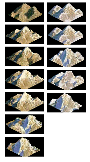
Heres some mountains I made sometime between 10-4. I don't know if theyre the right size for the tiles, but if the graphics engine sets mountains ontop of a tile and then lets them overlap, I think it'll work... I dunno I was just bored and I think I have insomnia. Need sleep. Download it if youre interested in new stuff. Its a ton better than the mountain thats already in the game.... Night night
Lalala its now 5:20  the new file will be on my next post... the new file will be on my next post...
Last edited by xxjiggawhoxx on 09-02-2003 at 16:16
|
|
| |
|
|
|
xxjiggawhoxx
|
|
Dallas, Tx
Dec 2002
time: 23:17
|
|
Hmm I didnt think about it covering up other tiles... I forgot that they'll cover up units and tiles behind it... I can shrink 'um I guess. I'll do it later though.
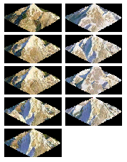
Anyway here are the new mountains. I made 5 or 6 more for the snow/tundra type terrain. (Is the object of this game to get it to look as real as possible or what?.. I usually hate the fake looking graphics on some games, but they need to look a bit cartoonish I think.) Btw, anytime I make graphics I'm gonna bunch them up by terrain type, and if they're to be used then I'll go through the trouble of seperating them. Ok, it's really, really, really late now and I should go to sleep. (or is it early?)
 Attachment: terrain001.bmp Attachment: terrain001.bmp
This has been downloaded 25 time(s).
Last edited by xxjiggawhoxx on 09-02-2003 at 16:49
|
|
| |
|
|
|
xxjiggawhoxx
|
|
Dallas, Tx
Dec 2002
time: 23:17
|
|
Okies I redid the mountains like Mark said. I didn't resize them to make them shorter, however I alligned them to where the top of the mountain was in the top corner of the tile, so there should be some overlapping, but not much. This is as much as I'm gonna do with mountains for now, cuz I'm really sick of looking at them. Heres the new download.
(Is there a way to attach it and put the image on the post or not?)
Attachment: terrain001.5.bmp
This has been downloaded 20 time(s).
|
|
| |
|
|
|
Martin the Dane
|
 |
Aarhus, Denmark
Feb 2000
time: 06:17
|
|
quote:
(Is there a way to attach it and put the image on the post or not?) |
Yes Tyler, just attach it as .gif, .jpg, or .png
Forgot to mention: nice mountains, I like 'em
Last edited by Martin the Dane on 25-02-2003 at 19:12
|
|
| |
|
|
|
Gary Thomas
|
 |
New Zealand
Mar 2001
time: 17:17
|
|
As far as putting all the tiles or units in one file, that is, essentially, a matter of taste. It does have some advantages for loading, since you need to open only one file handle. Once read in, the tiles can remain in one large image, or be disassembled and stored separately. It doesn't really make any difference. Java can pick out sub-images quite happily.
We did have someone who was keen on putting the images together (particularly the coastal ones) but he didn't do it. It never seemed to be a high priority for me (and still isn't).
The small number of images we have now hardly justify a whole lot of coding purely for the sake of some rather vague notion of organization.
When the number of separate images reaches around 2000, then perhaps we should organize. Even then sub-directories would do it.
On the other hand the existing system was explicitly designed so that an artist, with no programing ability, could change the images around to see how they looked. This is why the image index file exists. And this is the reason for the present system.
An odd thing about Clash. It has now reached the stage where virtully everything in it has been hashed over, discussed, voted on, and settled one way or another.
Disorganized is really the last word I would use. Short of resources? Yes. Let down by people who say they will do things then don't? Yes. But disorganized? No.
Cheers
|
|
| |
|
|
|
alms66
|
|
Louisiana
Oct 1999
time: 23:17
|
|
It appears Clash will definitely be going to polygons in the future, so I'm not sure how much this would ultimately help, but I'll post it anyway. I'm sure someone has thought of some of this already, it just may not have been done yet.
I haven't looked at the code, but I assume there is a tile ID member in there. What you need to do is add a graphic number member as well. This allows you to have several tile graphics for each type of terrain and identify them by tile type (grassland, plains, mountains, etc.) using tileID and by the tile graphic in the template or by filename if there are no templates as is the case now. Nothing new, I know, but by doing it this way, you open up the possibility of an infinite number of tiles. And why is this a good thing? Well for grassland, plains, tundra and desert 3 of each gives the map enough variety, without confusing or cluttering it. For hills and mountains, 5 or more varieties really adds alot to the look of the overall map (we had 7 in EIT, but it looked good with 5 too, the artist went back and added 2 later). But the main place having more than one image improves the look of the game, as I'm sure all of us know, is in the coastal tiles. With EIT we had 30, and it truly gave a stunning feel to the map. Almost as if you were looking at a real map of a real place. Let's just say it does wonders for player immersion.
When first creating the map then, you determine tile ID normally, and based on the number of tile graphics you have for that terrain type (let's call that number x), generate a random number between 1 and x and assign that as the graphic number. Obviously, don't hard code x, scan for it. Also, the graphic number isn't generated every time, it stays the same after creation, so the map doesn't look slightly different each time you load the game, obviously.
If Clash ever switches to using graphical templates I'd suggest the following layout:
ggg
ppp
ttt
mmmmm
hhhhh
cccccccccc....etc
with g=grassland, p=plains, t=tundra, m=mountains, h=hills, & c=coastal. With this layout, it's easy to add more tiles, even more tile types, which happened to us once.
 So this has all been very straight forward, logical, and while no one may have thought to do it exactly this way, it's all been done before. So why did I waste all this time and space spelling it out? Because of the text file you need in conjunction with all the above to work some magic. So this has all been very straight forward, logical, and while no one may have thought to do it exactly this way, it's all been done before. So why did I waste all this time and space spelling it out? Because of the text file you need in conjunction with all the above to work some magic.
First of all, let me say that we never actually got around to doing this part, we decided to tack it on to the end of the list of things to do, simply because we had the above working already and this adds extra eye candy and player immersion. It's not an essential component, but I think it will be well worth doing it. OK, so the text file has a heading for each tile type, and under that heading you have several columns of numbers (the tile graphic numbers). Each column is a grouping of tiles you'd like to keep together for random number generation purposes. For example, EIT had 30 coastal graphics for each direction. Some were drawn as beach, some as rocky coasts, some with cliffs, etc. So it looked something like this:
#COASTAL_SE#
1 .5 . 6.13
2 .7 .10.15
3 .8 .11.16
4 .9 .12.17
23.19.14
24.20.18
27.21.25
28.22.26
The first column was those grouped together as beach, and were placed anywhere the other conditions didn't exist. The second column was placed next to mountain or hill tiles because they had the cliffs. The third column, the rocky coast, went in the same locations the cliffs would be placed (using a random determination of cliffs or rocky coast). And the fourth column was the arctic column that was placed in the arctic, with icebergs and seals on the beach, etc.
So when determining the graphic number, don't apply the random number generated, match it to the number in the column and apply that number. For example, from the coastal snip above, placing an arctic tile I would need to generate a random number 1-4 since there are 4 numbers in that column, let's say a 3 came up. That would mean the graphic number member for that particular tile would be 16, so the file coastal_16 would be loaded and displayed there with all it's icebergs, seals and igloos.
Another good use for this system would be for forest overlays, especially since Clash will feature deforestation, though it can also represent partially forested areas without human intervention. Basically set it up like so:
#Forest#
1.6 .11.16
2.7 .12.17
3.8 .13.18
4.9 .14.19
5.10.15.20...and so on.
having the first column be 100% cover, the second 95%, the third 90%, etc.
Any comments/questions?
|
|
| |
|
|
|
yellowdaddy
|
 |
Saoir-Ebhor, Sasainn a tuath, Rialtas Aontach
Apr 2003
time: 05:17
|
|
how might this affect my "organic settlement" overlays idea...?
Me:
quote:
what about the ideas i've put forward on that front? areas of settlement/urbanisation as collections of little buildings which can form a range of city shapes, and |
Mark E:
quote:
I think your cocept is intriguing. However, I found the examples currently on your web page to be hard to discern from the terrain. Since cities need to be easily-resolved when placed on a wide range of terrain tiles, that isn't a trivial problem. Also, the coding infrastructure to handle something like that does not yet exist. But we did plan to do similar things for tile graphics for forests, where deforestation would show nearly-continuous thinning of trees. So I expect that the code to handle such things will be there at some point. However it's not a priority at the moment. That is why I expect Gary is asking for the traditional whole-tile cities for the moment. We will be using them for a significant amount of time I expect. |
Me:
quote:
The idea of having Flora, Fauna and Urban overlays growing, spreading, changing organically is truly an original and exciting game feature if implemented.There'll be implications for the military model as well as the economic model I imagin.
Gone are the days where you move a 1 square-filling mobile unit onto a 1 square-filling static unit (city) with two dimensional results, Bring on the polygon map and organic settlements!
Fair enough it's for the future, but I'll squeeze in a little digression, just as a mental note, i can shift it to a city overlays thread when we've got something relevant to D8 to post on one:
{How would you attack a swathe of mountain villages or }
{scattered farmsteads! you'd need to really develop the Task }
{Force idea, so you could add mongol horde-style raids perhaps.}
{different strategies too for coastal and riparian linear }
{settlements. }
{I suppose you'd need to assign admin centres or city }
{centres, as you click and draw your internal administration }
{borders, so that there is some defined place for an enemy to }
{capture, or which could potentially revolt and set up as another}
{citystate or part of another nationstate. }
{ }
{I think this would be a fascinating break from Civ where you }
{have strategic wars instead of just one-on-one unit battles. }
{ }
{When campaigning against sparse settlements and straggly }
{areas of settlement, you could capture each building one by }
{one, and thus have a defined area of control on the map, and }
{even end up in a stalemate where a large city is divided }
{between enemies. }
{ }
{As for the issue of visibility of these tiny buildings, well , one }
{solution is to have an urban background overlay - it needn't be }
{solid either - a grey/brown tint. And for the houses use more }
{contrast and shadows - i'll amend them. }
|
from here
-----------------------------------------------------------------------------------
I think the world has about or at least 12 (land) biomes worth having in a game:
Ice and Snow
Tundra
Boreal Forest
Deciduous Forest
Temperate Rainforest
Temperate Grassland
Savannah (Tropical Grassland)
Scrub (Dry forest)
Rocky Desert (including mountains)
Dunes
Tropical Rainforest (Jungle)
Temperate Marsh (Marsh/Bog)
Tropical Swamp
Moorland (including hills)
(I'm less keen on having "mountains" and forested hills as separate biomes)
plus:
Atoll/Reef
Sandbanks
Deep Sea
Shallow Sea
Freshwater
coastal:
sand beach
pebble beach
mud cliff
rocky cliff
rocks
mangrove
lagoon
spit
I had a list somewhere... add you're tuppence (2 cents if you're Johnny Foreigner! )
|
|
| |
|
|
|
LDiCesare
|
|
La Ferté sous Jouarre France
Jan 2001
time: 05:17
|
|
Adding a pointer to which graphics we use instead of just terrain is perfetly ok. The main limitations are:
-Graphics (eince we don't have many tiles or variants, there was no need to have variants in the code).
-Features spanning more than one tile.
These are usually mountains and rivers, though between tile rivers don't necessarily need it. Mountain ranges require some tuning to get two-tiles and such (as was done in civ2 ToT if I remember well).
As for having numbers, naming conventions for the tiles and graphics: We use a set of xml files (you can dig them in the jar of the demos) which precise all kinds of things, including terrain. Having a list of graphics for one kind of terrain is quite straightforward. We may want to either let the program find a random one or let the map designer precise the variant when making the xml file (this would require a map editor but it will still end as a xml file).
|
|
| |
|
|
|
alms66
|
|
Louisiana
Oct 1999
time: 23:17
|
|
I'd be willing to do some tile graphics. I'm no good with humans and animals, but for things like trees, mountains, hills, etc., I can do a fairly good job. Is Clash able to handle only one size of tile? If so, I could just use the existing ones as a guide. But I seem to remember that any tile size divisible by two would work, or am I crazy?
Last edited by alms66 on 26-05-2004 at 12:04
|
|
| |
|
|
|
PresidentMarcos
|
|
What about wastelands?
|
|
| |
|
|
|
alms66
|
|
Louisiana
Oct 1999
time: 23:17
|
|
Wastelands? As in what exactly. Give me some real-world example of a wasteland.
I'll take a stab at the irrigation, then rivers after. I guess just one variation would suffice for now, right? Also, the irrigation will work as an overlay, correct?
|
|
| |
|
|
|
Max Sinister
|
|
About Wasteland:
Farmland that has been exploited for too much time and became infertile?
Bare rocks?
Salted lands (a big problem in hot regions where fields have to be irrigated, like in Egypt, f.e.)?
Polluted / poisoned lands?
Or even radioactive? If it's for a scenario playing during the dawn of history, certainly not...
|
|
| |
|
|
|
PresidentMarcos
|
|
Well, a general wasteland. Like, the Sahara after the cow-keepers got at it. Not quite a desert, but for the time being, barren and not a very nice place for life to thrive.
|
|
| |
All times are GMT. The time now is 05:17.
Apolyton Time is 00:17. |
top of page
|
|
|
Forum Rules:
You may not post new threads
You may not post replies
You may not post attachments
You may not edit your posts
|
HTML code is ON
vB code is ON
Smilies are ON
[IMG] code is ON
|
|
|
|
|
|





 05-02-2003 08:46





 , so I can draw some more. I'll probably start by doing all the tiles in the style I had started a long time ago. I had all the pictures somewhere, so I'll go ahead and do that, and even if you don't use it for the game they still work for Civ2 or Freeciv, so they're basically for me. I skimmed over what you all were writing, and it seems like you're busy with resources, so I'll help with that if you need. I think what would be even better once the game is completed is if all the artists that worked on it made their own tilesets and graphics. More variety = more fun! Anyway I've got to go apply for a job so I'll see y'all later.

 |
|